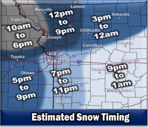
Snowfall is expected to arrive in two waves today, according to the National Weather Service.
While flurries are possible early today, the first wave of snow is expected mainly after 4 p.m., the weather service said. Then another wave of snow is likely, from after sunset to before 11 p.m., according to the weather service.
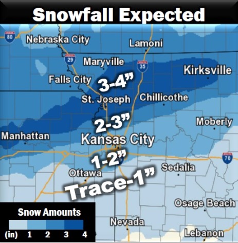
Areas to the north of Kansas City area, north of the Missouri River, including St. Joseph, Missouri, to Kirksville, Missouri, may see the highest possible totals of 2 to 4 inches, with a possible 4-plus inches in localized areas. South of the Missouri River, there will be anywhere from a trace to 2 inches, and amounts were not certain as of this morning, according to forecasters.
In the Kansas City area, daytime snowfall could be less than 1 inch, after 4 p.m. Another inch of snow is possible in the Kansas City area before 11 p.m.
Snow will move in from the west, and while the morning commute in the Kansas City area may be unaffected by snow, the afternoon or evening commute could see a significant amount north of the Missouri River, according to the weather service.
There may be issues with travel between 7 p.m. and 9 p.m. today during the extended evening commute in the Kansas City area, the weather service said. The snowfall may end from west to east tonight, around midnight.
Today, the high will be near 21 with wind chill values between zero and 10, the weather service said. A calm wind will become northeast 5 to 8 mph in the morning. There is a 60 percent chance of snow. Less than one inch of snow is expected during the daytime hours.
Tonight, there is a 60 percent chance of snow, mainly before 11 p.m., according to the weather service. The low will be around 10 with a northeast wind of 5 to 7 mph becoming northwest after midnight. Around an inch of snow is possible tonight.
Wednesday, the high will be near 30 with sunny skies and a northwest wind of 6 mph, the weather service said.
Wednesday night, the low will be around 19, with a calm wind becoming south 5 to 8 mph after midnight, according to the weather service.
Thursday, the high will be near 47 with mostly sunny skies and a south southwest wind of 8 to 13 mph, gusting as high as 24 mph, the weather service said.
Thursday night, the low will be around 25 with mostly cloudy skies, according to the weather service.
Friday, the high will be near 30 with mostly cloudy skies, the weather service said.
Friday night, the low will be around 20 with a 30 percent chance of snow, according to the weather service.
Saturday, there will be a 40 percent chance of snow with a high near 29, the weather service said.
Saturday night, expect a 30 percent chance of snow before midnight, with a low of 17, according to the weather service.
Sunday, the high will be near 30 with partly sunny skies, the weather service said.
Sunday night, the low will be around 17 with mostly cloudy skies, according to the weather service.
Monday, the high will be near 41 with mostly cloudy skies, the weather service said.