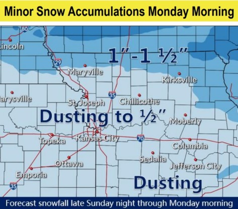
Minor snow accumulation is forecast for Sunday night into Monday morning, according to the National Weather Service.
Areas north of Highway 36, near the St. Joseph, Missouri, area, are forecast to receive an inch of snow or slightly higher, the weather service said.
Cold temperatures will move in for Monday and Tuesday.
Highs will be below freezing and wind chills on Tuesday morning will drop into the single digits throughout the area, according to the weather service.
Today, it will be sunny with a high near 56 and a northeast wind around 6 mph, the weather service said.
Tonight, there will be a 40 percent chance of rain and snow showers before 3 a.m., then a chance of snow showers after 4 a.m., according to the weather service. The low will be around 27, with a northeast wind of 6 to 16 mph, gusting as high as 25 mph. Less than a tenth of an inch of snow is in the forecast here.
Monday, Veterans Day, snow showers are likely, mainly before 9 a.m., with a 60 percent chance of snow, the weather service said. The high will be near 28 with a north wind of 11 to 16 mph, gusting to 30 mph. Less than a half-inch of snow is in the forecast.
Monday night, it will be mostly clear, with a low of 14 and a north wind of 5 to 10 mph, becoming light after midnight, according to the weather service. Winds may gust as high as 20 mph.
Tuesday, it will be sunny with a high near 31 and a calm wind, the weather service said.
For more weather information, visit www.weather.gov.