Blast of cold air to last through mid-February
Snow will be in the forecast for Saturday, according to the National Weather Service.
Light snow will move in from the west to the east, and last through late morning or early afternoon, the weather services said. There could be four to six hours of snow.
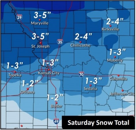
Wyandotte County could receive 2 to 4 inches of snow Saturday, according to the forecast. Snow could be moderate to heavy at times.
A stretch of sub-freezing temperatures is expected to last through the weekend and next week, the weather service said. This will be a significant stretch of sub-freezing temperatures, that may last into the middle part of February. It could last beyond mid-February, also, according to the weather service.
There will be chances of off and on snow through next week, but at this time none of these rounds of snow appear to have high impact accumulation, according to the weather service.
Today, it will be partly sunny with a high near 42 and a northwest wind of 5 to 9 mph, the weather service said.
Tonight, there will be increasing clouds, with a low of 21 and a north wind of 5 to 8 mph becoming east after midnight, according to the weather service.
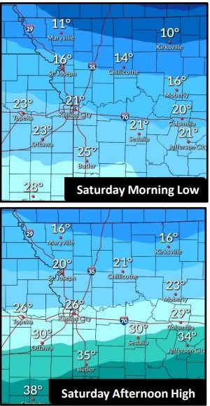
Saturday, there is a 60 percent chance of snow with a high near 26, the weather service said. An east wind of 8 to 13 mph will become north in the afternoon, and winds may gust up to 20 mph. New snow accumulation of 2 to 4 inches is possible.
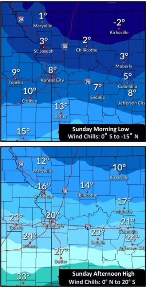
Saturday night, it will be mostly cloudy, with a low of 8, according to the weather service, and wind chill values of between minus 2 to 3. There will be a north northeast wind of 7 to 9 mph.
Sunday, it will be cloudy, with a high near 21 and an east wind of 8 to 10 mph, the weather service said.
Sunday night, it will be mostly cloudy, with a low of 11, according to the weather service.
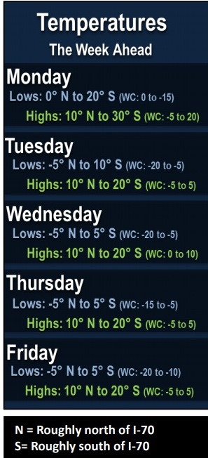
Monday, there is a 30 percent chance of snow with a high near 21, the weather service said.
Monday night, it will be mostly cloudy, with a low of 3, according to the weather service.
Tuesday, it will be partly sunny and cold, with a high near 14, the weather service said.
Tuesday night, it will be mostly cloudy, with a low of 2, according to the weather service.
Wednesday, it will be partly sunny, with a high near 16, the weather service said.
Wednesday night, it will be mostly cloudy, with a low of 3, according to the weather service.
Thursday, it will be mostly cloudy and cold, with a high near 15, the weather service said.
For more weather information, visit www.weather.gov.