Snow is in the forecast for Monday night into early Tuesday morning in an area to the north and west of Wyandotte County, according to the National Weather Service.
Rain is possible tonight and should leave the Wyandotte County area around midnight, when temperatures are predicted to be around 35 degrees, according to a weather service chart. Temperatures will drop to 33 around 2 a.m. Tuesday, and at 5 a.m. Tuesday could be around 30 degrees.
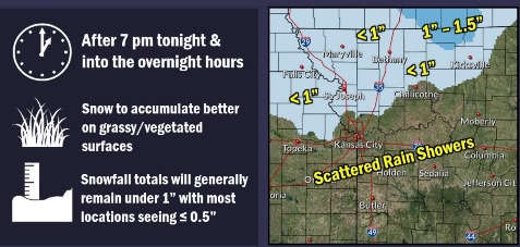
Snow then may arrive in Wyandotte County on Tuesday night and Wednesday morning, the weather service said.
On Wednesday night, freezing drizzle will be possible, according to the weather service forecast.
On Thursday and Thursday night, Halloween, chances of snow continue to be in the forecast for Wyandotte County, the weather service said.
Below normal temperatures are expected through next week, according to the weather service. Wind chills may drop into the teens and low 20s Thursday morning.
The Missouri River at Parkville, where the gauge is on I-435 over the Missouri River between Wyandotte and Platte counties, is below minor flood stage and has dropped below action stage. The Missouri River at Atchison is in action stage, and the Missouri River at St. Joseph, Missouri, is in minor flood stage, according to hydrology charts.
Today, there will be a 40 percent chance of rain, mainly after 4 p.m., the weather service said, with a high near 41 and a north wind of 7 to 9 mph. Less than a tenth of an inch of rain is possible.
Tonight, there is a 70 percent chance of rain, mainly before 10 p.m., according to the weather service. Skies will be cloudy with a low of 29 and a north wind of 5 to 10 mph, gusting as high as 18 mph. Between a tenth and quarter-inch of rain is possible.
Tuesday, it will be partly sunny, with a high near 42, the weather service said, and a light north wind becoming northeast 5 to 9 mph in the morning.
Tuesday night, there is a 70 percent chance of drizzle and snow likely before 1 a.m., then snow likely, possibly mixed with rain, according to the weather service. The low will be around 32 with a northeast wind of 5 to 7 mph. Less than one inch of snow is possible.
Wednesday, there is a 70 percent chance of rain and snow likely before noon, then drizzle likely between noon and 1 p.m., the weather service said. The high will be near 37 with a northeast wind of 8 to 10 mph, gusting as high as 24 mph. New snow accumulation will be less than a half-inch.
Wednesday night, there is a 50 percent chance of drizzle, possibly mixed with snow before midnight, then freezing drizzle likely, possibly mixed with snow, according to the weather service. The low will be around 27. New precipitation amounts will be between a tenth and quarter of an inch.
Thursday, there is a 30 percent chance of drizzle before 3 p.m., then a chance of drizzle between 3 p.m. and 5 p.m., then a chance of drizzle and snow after 5 p.m., the weather service said. The high will be near 37.
Thursday night, there is a 30 percent chance of snow before 7 p.m., according to the weather service, with a low of 23.
Friday, it will be sunny with a high near 43, the weather service said.
Friday night, it will be partly cloudy, with a low of 28, according to the weather service.
Saturday, it will be sunny with a high near 46, the weather service said.
Saturday night, it will be partly cloudy, with a low of 31, according to the weather service.
Sunday, it will be mostly sunny, with a high near 52, the weather service said.