After a high of about 61 today, the weather will change to colder and more wintry.
Quite a few different weather hazards are in the forecast for the next several days, including snow and ice on the weekend, cold temperatures, rain today and Friday, a wind advisory today, and flash flooding in parts of the region, according to the National Weather Service.
Wyandotte County is under a wind advisory until noon today, with wind gusts of up to 46 mph possible, according to the weather service.
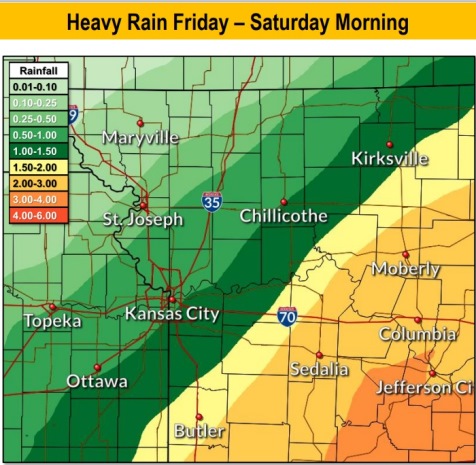
A strong storm system will bring periods of heavy rain, transitioning to freezing rain and snow to the area this weekend, the weather service said.
Rain is possible Friday morning through Saturday morning in Wyandotte County, according to the forecast.
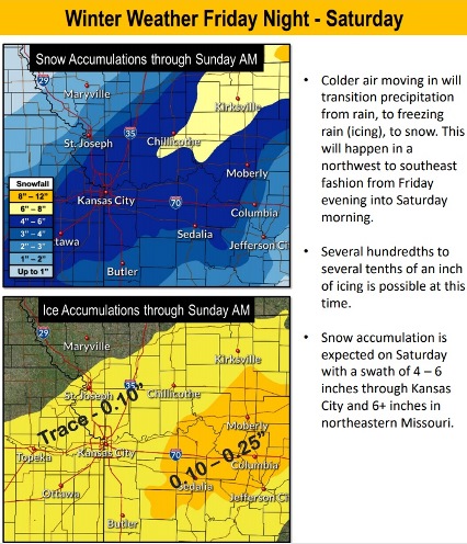
Accumulating ice and snow are likely with this storm from Friday evening through late Saturday night, according to the weather service.
The precipitation will change from rain to freezing rain, ice and then to snow, the weather service said. It will move from northwest to southeast from Friday evening into Saturday morning.
Several hundreds to several tenths of an inch of ice is possible at this time, according to the weather service.
Snow accumulation is expected on Saturday, with 4 to 6 inches possible in the Kansas City area, the weather service said.
Today, there is a 20 percent chance of drizzle before 1 p.m., then a slight chance of showers or drizzle between 1 p.m. and 3 p.m., and a slight chance of showers after 3 p.m., the weather service said. The high will be near 61. A south southwest wind of 19 to 24 mph will decrease to 9 to 14 mph in the afternoon. Winds may gust as high as 46 mph.
Tonight, there is a 30 percent chance of showers, mainly after 3 a.m., according to the weather service. There will be a low of 38, with a west wind of 5 to 8 mph becoming north northeast after midnight. Less than a tenth of an inch of rain is possible.
Friday, there is a 100 percent chance of showers, with a high near 41, the weather service said. A north northeast wind of 9 to 15 mph will gust as high as 28 mph. Between a tenth and quarter-inch of rain is possible.
Friday night, there is a 90 percent chance of precipitation, according to the weather service. There will be rain showers, snow showers and sleet, possibly mixed with freezing rain before 10 p.m., followed by snow showers, possibly mixed with freezing rain and sleet between 10 p.m. and 11 p.m., then snow showers, possibly mixed with freezing rain after 11 p.m. The low will be around 19 with a north wind of 13 to 16 mph, gusting as high as 31 mph. New ice accumulation of less than a tenth of an inch is possible. New snow and sleet accumulation of less than 1 inch is possible.
Saturday, there is a 50 percent chance of snow, with a high near 25, the weather service said. A north wind of 6 to 13 mph will gust as high as 25 mph.
Saturday night, it will be partly cloudy, with a low of 13, according to the weather service.
Sunday, it will be mostly sunny, with a high near 38, the weather service said.
Sunday night, it will be partly cloudy, with a low of 23, according to the weather service.
Monday, it will be partly sunny, with a high near 47, the weather service said.
Monday night, it will be mostly cloudy, with a low of 34, according to the weather service.
Tuesday, it will be mostly sunny, with a high near 47, the weather service said.
Tuesday night, it will be partly cloudy, with a low of 24, according to the weather service.
Wednesday, it will be partly sunny, with a high near 36, the weather service said.
For more weather information, visit www.weather.gov.