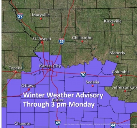
A winter weather advisory is in effect through 3 p.m. Monday in Wyandotte County.
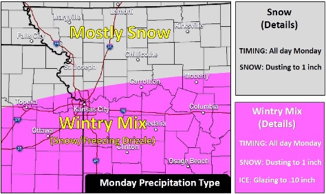
Light snow and freezing drizzle will persist off-and-on through the day, especially south of I-70, according to the forecast from the National Weather Service.
There will be minor accumulations, causing slick roads. North of I-70, there might be an inch or less of snow, the weather service said.
A light glaze of drizzle has fallen on streets and sidewalks. Winter precipitation is expected to move out by this evening, according to the weather service.
Residents are advised to slow down and use caution while driving, the weather service said. Also, dangerous wind chills will create hazardous conditions for anyone needing to go outdoors.
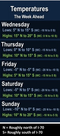
A prolonged stretch of sub-freezing temperatures will continue for the next several days, leading into the middle part of February, the weather service said. Several days with well-below zero wind chills are in the forecast through the middle of the month.
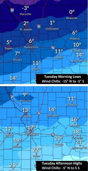
The temperature was 6 degrees at 9 a.m. Monday, with a wind chill of minus 7, and was expected to rise to a high of 12 today, according to the weather service.
Today, there is a 40 percent chance of snow and freezing drizzle before 3 p.m., then a chance of snow, the weather service said. The high will be near 12 with wind chill values between minus 3 and 2. There will be a north northeast wind of 7 to 9 mph. Less than a tenth of an inch of precipitation is in the forecast.
Tonight, there is a 30 percent chance of snow before 7 p.m., according to the weather service. The low will be around 4 with wind chill values between minus 2 and minus 7. There will be a north northeast wind of 7 to 9 mph.
Tuesday, it will be mostly cloudy, with a high near 17, the weather service said. The wind chill will be between minus 9 and 1. A northeast wind will be around 9 mph.
Tuesday night, it will be cloudy, with a low of 11 and a northeast wind of 7 to 9 mph, according to the weather service.
Wednesday, there is a 20 percent chance of flurries with a slight chance of snow after 1 p.m., the weather service said. The high will be near 19 with a northeast wind of 8 to 10 mph.
Wednesday night, there is a 20 percent chance of flurries with a slight chance of snow before 7 p.m., then a slight chance of snow after 1 a.m., according to the weather service. The low will be around 7.
Thursday, there is a 30 percent chance of snow between 7 a.m. and 1 p.m., then a chance of flurries after 1 p.m., the weather service said. The high will be near 14.
Thursday night, there is a chance of flurries before 7 p.m., with a low of 2, according to the weather service.
Friday, it will be mostly cloudy and cold, with a high near 13, the weather service said.
Friday night, it will be mostly cloudy, with a low of 1, according to the weather service.
Saturday, it will be mostly cloudy and cold, with a high near 14, the weather service said.
Saturday night, it will be mostly cloudy, with a low of minus 4, according to the weather service.
Sunday, it will be mostly cloudy, with a high near 16, the weather service said.
For more weather information, visit www.weather.gov.