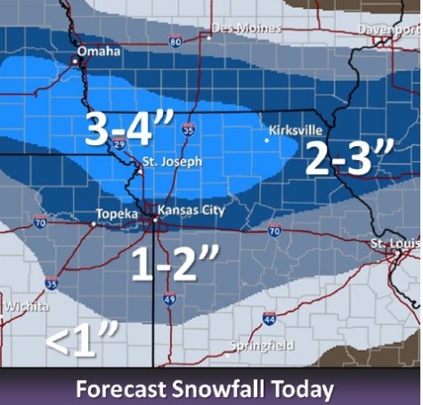
Snow is on the way this morning, and the National Weather Service says one to three inches of snow are possible.
A winter weather advisory is in effect from 9 a.m. today through 6 p.m. tonight, the weather service said.
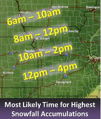
A quick-moving storm with light accumulation is expected to move through the region today, starting in the north and working its way south, according to the weather service.
The area with the highest snow accumulation will be north of I-70, the weather service said. Areas south of I-70 may receive less than an inch of snow, according to forecasters.
There could be higher amounts of snowfall in areas by the time the snow ends this evening, according to the weather service.
Gusty winds will combine with the light snow to bring visibilities down to below 1 mile at times, the weather service said.
Temperatures were 26 degrees at 9 a.m., with a wind chill of 15, according to the weather service.
Temperatures may fall to 18 degrees by 5 p.m., the weather service said. The north wind of 13 to 18 mph may gust as high as 28 mph, according to the forecast. Tonight, the low will be 4 degrees.
The weather service warned that travel may become difficult during the afternoon hours because of snow and blowing snow.
The winter weather advisory means that periods of snow, sleet or freezing rain will cause travel difficulties. Residents should be prepared for slippery roads and limited visibility and use caution while driving, the weather service said.