
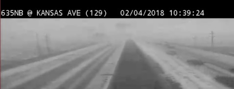
Snow was falling in parts of Wyandotte County around 10 a.m. Sunday.
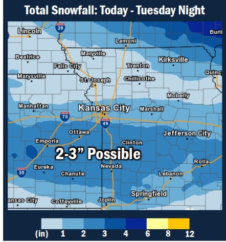
Light snow is expected today, according to the National Weather Service. The high was 21 at 10 a.m. Sunday, with a wind chill of 8 degrees.
More snow is expected on Tuesday, the weather service said.
According to the weather service, snow is possible before 1 p.m. today, and it will gradually clear. There will be a high near 22. A north wind of 11 to 17 mph will gust as high as 25 mph.
Tonight, it will be mostly clear with a low of 13 and a north wind of 5 to 9 mph becoming calm, according to the weather service.
Monday, it will be partly sunny with a high near 36, the weather service said. A south southeast wind of 5 to 10 mph will become northwest in the afternoon.
Monday night, the low will be around 19 with a light north wind, increasing to 5 to 9 mph in the evening.
Tuesday, there is a 60 percent chance of precipitation as snow is likely after noon, the weather service said. The high will be near 25. One to two inches of snow are expected.
Tuesday night, there is a 60 percent chance of snow, mixing with freezing rain, after 11 p.m. The low will be around 13. Less than a tenth of an inch of snow is expected.
Wednesday, the high will be near 32 with sunny skies, the weather service said.
Wednesday night, the low will be around 18 with mostly clear skies, according to the weather service.