Light rain will move into the area this afternoon, particularly across northern Missouri, according to the National Weather Service.
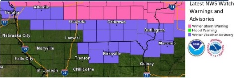
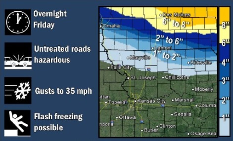
Rain will mix with and change to snow overnight, mainly across areas north of US 36 Highway (north of the St. Joseph, Mo., area). These areas could see one to three inches of snow by Saturday morning, the weather service said.
Quickly falling temperatures and gusty winds to 35 mph could make for hazardous driving conditions into early Saturday morning, and a winter weather advisory is in effect for these areas, the weather service said.
Further south, rain could mix with a few snowflakes overnight but no accumulation is expected.
Today’s forecast for Wyandotte County is a 60 percent chance of rain, mainly after 5 p.m., with a high near 51, the weather service said. There will be a south southeast wind of 9 to 13 mph.
Tonight, rain is likely before 3 a.m., then a slight chance of snow, the weather service said. The chance of precipitation is 70 percent, and little or no snow accumulation is possible, according to the weather service. The low will be around 29. It will be blustery, with a south southwest wind of 6 to 11 mph becoming north northwest 16 to 21 mph after midnight, and gusts up to 29 mph.
On Saturday, it will be partly sunny, then gradually becoming sunny, with a high near 36, the weather service said. There will be a north northwest wind of 8 to 18 mph, with gusts as high as 26 mph.
Saturday night, expect a low of 23, partly cloudy skies, and a light and variable wind becoming south southwest 5 to 7 mph after midnight, according to the weather service.
On Sunday, it will be sunny with a high near 46 and a southwest wind of 7 to 10 mph, according to the weather service.
Sunday night, it will be clear with a low of 31, the weather service said.
Monday’s high will be near 54 with sunny skies, the weather service said.