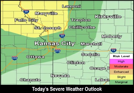
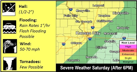
Wyandotte County is in a marginal risk area for severe thunderstorms today, according to the National Weather Service.
There is a 20 percent chance of showers and thunderstorms between 8 p.m. and 5 a.m., the weather service said.
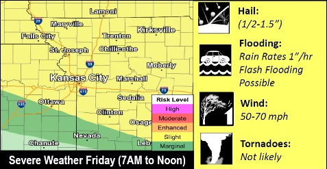
Storms today may have large hail, damaging winds and tornadoes, according to the weather service. Severe storms also are possible early Friday morning and Saturday night.
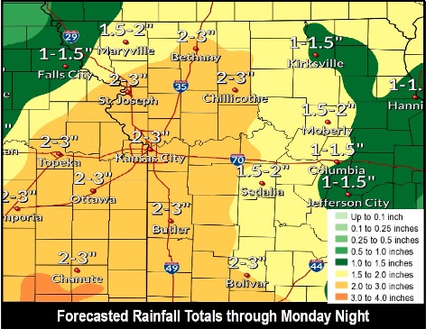
Heavy rain will be possible during multiple rounds of rainfall through the weekend, the weather service said. Two to three inches of rain are possible.
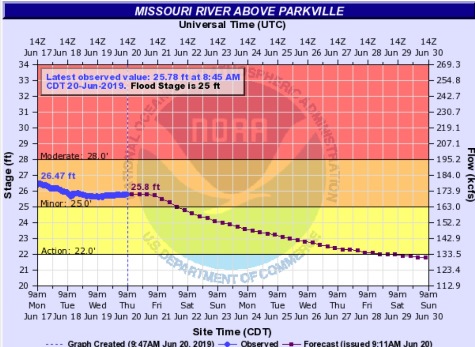
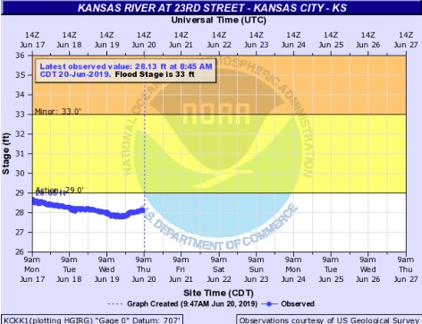
Rain throughout the region could have an effect on flooding. Missouri River flooding continues, with the Missouri River at Parkville in minor flood stage. The Kansas River at 23rd Street is below flood stage.
Today, it will be sunny with a high near 87 and a light south southwest wind becoming south 5 to 9 mph in the afternoon, the weather service said.
Tonight, there is a 20 percent chance of showers and thunderstorms between 8 p.m. and 5 a.m., with a low around 70. A south southeast wind of 7 to 9 mph is forecast, according to the weather service.
Friday, there will be a slight chance of showers and thunderstorms after 8 a.m., with a high near 91, the weather service said. Heat index values will be as high as 99. A south southeast wind will be 8 to 15 mph, gusting as high as 23 mph.
Friday night, there is a 20 percent chance of showers and thunderstorms, with a low of 74, according to the weather service. There will be a south wind of 10 to 13 mph, with gusts as high as 26 mph.
Saturday, there is a 40 percent chance of showers and thunderstorms, mainly after 2 p.m., the weather service said. The high will be near 90 with a south southwest wind of 7 to 10 mph, gusting as high as 22 mph. Less than a tenth of an inch of rain is expected.
Saturday night, there is a 70 percent chance of showers and thunderstorms, after 8 p.m. The low will be around 70. Between 1 and 2 inches of rain are possible.
Sunday, there is a 60 percent chance of showers and thunderstorms, before 2 p.m. The high will be near 84.
Sunday night, there is a 40 percent chance of showers and thunderstorms, with a low of 65, according to the weather service.
Monday, there is a 40 percent chance of showers and thunderstorms before 8 a.m., with a high near 83, the weather service said.
Monday night, it will be mostly clear with a low of 64, according to the weather service.
Tuesday, it will be sunny with a high near 88, the weather service said.
Tuesday night, it will be mostly clear, with a low of 68, according to the weather service.
Wednesday, it will be mostly sunny, with a high near 89, the weather service said.
For more weather information, visit www.weather.gov.