Rain showers are expected on-and-off today, according to the National Weather Service forecast.
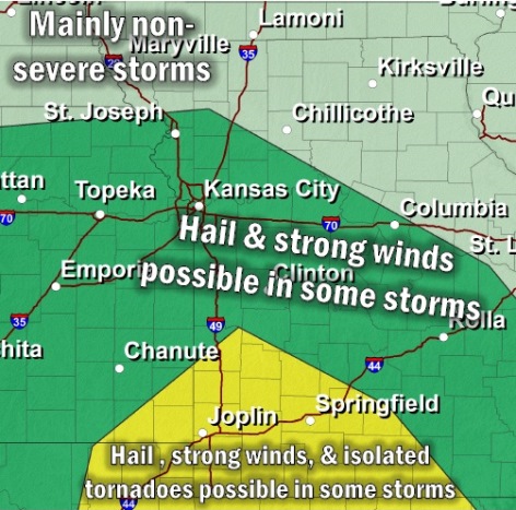
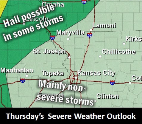
Late tonight, there is a small chance for severe weather north of the Kansas City area. Hail up to 1 inch is the primary threat, according to the weather service.
Widespread thunderstorms return Friday morning through Saturday evening for the entire forecast area. A few storms could be severe, the weather service said.
Another round of storms is possible Sunday night into Monday, according to the weather service. No hazardous weather is expected at this time.
Widespread thunderstorms return Friday morning through Saturday evening for the entire forecast area, the weather service said.
A few storms could become severe, mainly in the afternoon or evening Friday, according to the weather service. Gusty winds up to 60 mph and hail up to 1 inch are the primary threats. The tornado potential is low at this time.
Localized flooding is also possible in areas that see multiple storms, the weather service said. By Saturday evening, some areas could see around 0.5 inches of rain, with other areas to the south seeing around 1 inch.
Today’s forecast in Wyandotte County calls for patchy drizzle with a 30 percent chance of showers before noon, according to the weather service. It will be cloudy, then will gradually become mostly sunny, with a high near 76. A south wind will be 9 to 17 mph, gusting to 26 mph. Less than a tenth of an inch of rain is expected.
Tonight, the low will be around 61 with partly cloudy skies, according to the weather service. A south wind will be around 15 mph, gusting to as high as 22 mph.
Friday, there is a 70 percent chance of showers and thunderstorms, mainly after 1 p.m., the weather service said. The high will be near 70. A south wind of 14 to 16 mph will gust as high as 31 mph. Rainfall amounts may be between a tenth and quarter of an inch.
Friday night, there is a 70 percent chance of showers and thunderstorms before 10 p.m., then showers are likely and possibly a thunderstorm between 10 p.m. and 4 a.m., followed by rain after 4 a.m., the weather service said. The low will be around 51. A south southeast wind of 5 to 10 mph will become light and variable after midnight. Between a tenth and a quarter of an inch of rain may fall.
Saturday, there is a 50 percent chance of showers, with a high near 59, according to the weather service. A north northwest wind will be 6 to 10 mph. Between a tenth and quarter of an inch of rain is possible.
Saturday night, it will be mostly cloudy with a low of 44, the weather service said.
Sunday, it will be partly sunny with a high near 65, according to the weather service.
Sunday night, there is an 80 percent chance of showers, mainly after 1 a.m., the weather service said. The low will be around 49.
Monday, there is a 70 percent chance of showers, mainly before 1 p.m. The high will be near 63.