Rain fell this morning in Wyandotte County, and more scattered showers and a few thunderstorms are possible on Tuesday, according to the National Weather Service.
The chance of rain is 60 percent mainly before 1 p.m. today, the weather service said. After 1 p.m., precipitation chances will gradually diminish.
Cooler temperatures are expected behind the cold front, with highs in the lower to mid-70s and lows dropping down into the upper 40s to lower 50s, according to the weather service.
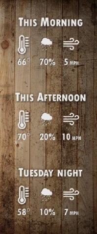
Today, the high will be near 69 in Wyandotte County, with rain, storms, cloudy skies and a north northwest wind of 5 to 8 mph, the weather service said. Between a tenth and a quarter-inch of rain is possible.
Tonight, it will be mostly cloudy with a low of 57 and a north wind around 7 mph, according to the weather service.
Wednesday, the high will be near 71 with partly sunny skies and a north northeast wind of 6 to 8 mph, the weather service said.
Wednesday night, the low will be around 52 with partly cloudy skies and a north northeast wind of 3 to 6 mph, according to the weather service.
Thursday, expect mostly sunny skies and a high of 74, the weather service said, with a calm wind that becomes north around 5 mph in the afternoon.
On Thursday night, the low will be 54 with partly cloudy skies, according to the weather service.
Friday, it will be mostly sunny with a high of 75, the weather service said.
Friday night, expect a low of 52 with partly cloudy skies, according to the weather service.
Saturday’s skies will be mostly sunny with a high of 73, the weather service said.
Saturday night, the low will be 55 with partly cloudy skies, according to the weather service.
Sunday, the high will be near 75 with mostly sunny skies, the weather service said.