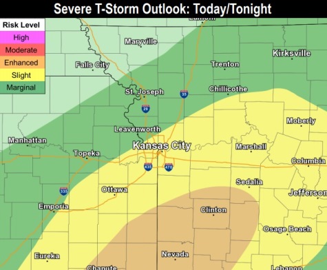
Severe weather is in the forecast for this afternoon and evening, according to the National Weather Service.
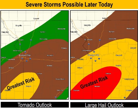
The region will be under a severe thunderstorm risk from 4 p.m. to 10 p.m. Wednesday, the weather service said. Wyandotte County is in an area of slight risk.
Damaging winds and golf-ball sized hail could be possible with these storms. Tornado development is possible with the strongest isolated thunderstorms, according to the weather service.
The greatest risk of these severe storms today will be south of I-70, and in an area to the south of the Kansas City metropolitan area that includes Chanute, Kansas, and Nevada, Missouri.
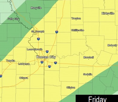
The chance of severe storms increases on Friday in Wyandotte County, as compared to Thursday.
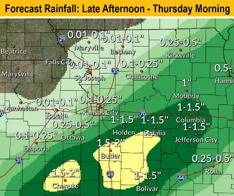
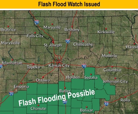
Heavy rain is expected tonight in areas with already saturated ground, the weather service said. There will be river flooding concerns, and new heavy rainfall will prolong flooding along the Missouri River and lead to new flooding on its tributaries.
From a quarter to a half-inch of rain could fall from late afternoon to Thursday morning in Wyandotte County, according to the forecast.
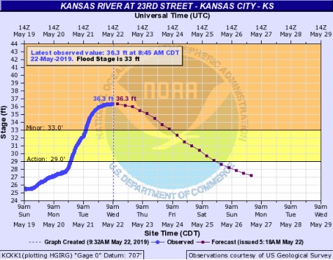
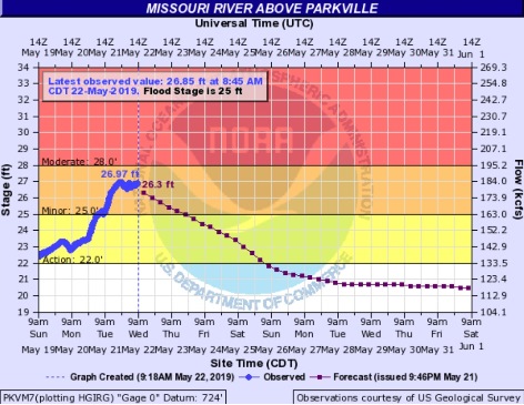
The flood warnings continue for these locations affecting Wyandotte County: the Kansas River at 23rd Street; the Missouri River at Parkville; and the Missouri River at Kansas City. Residents are advised not to drive through flowing water. As little as 6 inches of water can cause drivers to lose control of their vehicles. Two feet of water can carry most vehicles away, according to the weather service.
The flood warning continues until Saturday morning for the Kansas River at 23rd Street. The gauge for this location is Kansas Avenue at the state line. At 4:45 a.m. Wednesday, the stage was 36.2 feet, where flood stage is 33 feet. Minor flooding is occurring. The river will continue rising to near 36.3 feet by this afternoon, then fall below flood stage on Friday morning. At 33 feet, the river floods undeveloped woodland along the river and outside of the levee protection. No flooding of areas behind the levees is expected.
The flood warning for the Missouri River at Parkville, which includes the Wyandotte County area, is in effect until Friday evening. At 4:45 a.m. Wednesday the stage was 26.8 feet, where flood stage is 25 feet. Minor flooding is occurring. The river will fall below flood stage by Thursday evening.
The flood warning for the Missouri River at Kansas City continues until Thursday evening. This gauge is on U.S. 169 and the Missouri River, near the City Market in Kansas City, Missouri. At 4:30 a.m. Wednesday the stage was 31.9 feet, where flood stage is 32 feet. Minor flooding is forecast. The river may rise above flood stage early this morning and continue to rise to near 32.3 feet today, then fall below flood stage this evening. At 32 feet, minor flooding outside the levees occurs.
Today, it will be sunny with a high near 76 and a south southwest wind of 9 to 14 mph, gusting to 22 mph, the weather service said.
Tonight, there is a 50 percent chance of showers and thunderstorms after 8 p.m., with a low of 63. A southwest wind of 6 to 11 mph will become light and variable. Between a quarter and half-inch of rain is possible.
Thursday, there is a 40 percent chance of showers and thunderstorms, with a high near 78, the weather service said. The wind will be from the east at 5 to 8 mph. Less than a tenth of an inch of rain is expected.
Thursday night, there is a 30 percent chance of showers and thunderstorms, mainly before 2 a.m., according to the weather service, with a low of 70 and a southeast wind of 8 to 13 mph. Less than a tenth of an inch of rain is expected.
Friday, there is a 40 percent chance of showers and thunderstorms, mainly after 8 a.m., the weather service said. The high will be near 79 with a south southwest wind of 11 to 14 mph, gusting as high as 24 mph. Less than a tenth of an inch of rain is possible.
Friday night, there is an 80 percent chance of showers and storms, and then more showers and possibly a thunderstorm after 2 a.m., according to the weather service. The low will be around 65. Between 1 and 2 inches of rain are possible.
Saturday, there is an 80 percent chance of showers and possibly a thunderstorm before 8 a.m., then a chance of showers and thunderstorms after 8 a.m., the weather service said. The high will be near 80.
Saturday night, there is a 70 percent chance of showers and thunderstorms, mainly after 2 a.m., according to the weather service. The low will be around 65.
Sunday, there is a 70 percent chance of showers and thunderstorms, with showers and storms likely before 8 a.m., then a chance of showers and thunderstorms after 2 p.m., the weather service said. The high will be near 80.
Sunday night, there is a 60 percent chance of showers and thunderstorms, then showers are likely after 2 a.m., according to the weather service. The low will be around 65.
On Monday, Memorial Day, there is a 60 percent chance of showers, with a high near 81, the weather service said.
Monday night, it will be mostly cloudy with a low of 65, according to the weather service.
Tuesday, there is a 40 percent chance of showers and thunderstorms, with a high near 80, the weather service said.