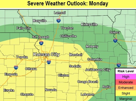
Strong to severe storms could develop this afternoon and evening, according to the National Weather Service.
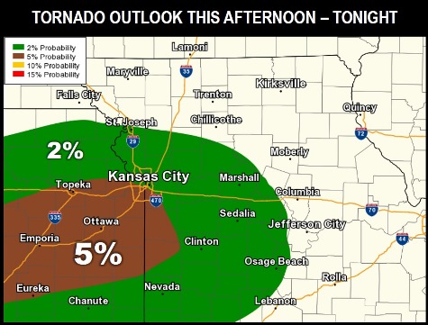
Tornadoes could be possible with initially developing storms in the region, the weather service said.
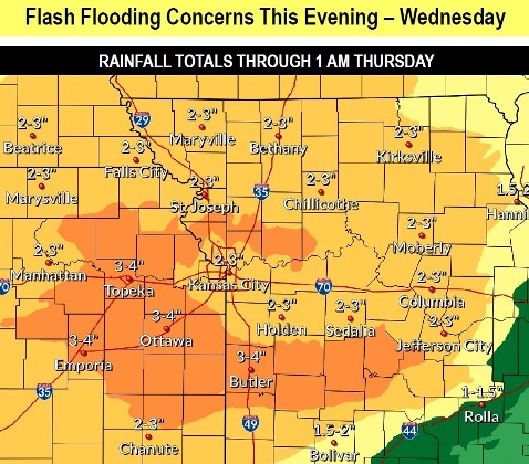
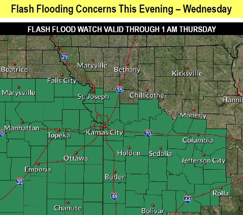
Hail, wind, heavy rain and flash flooding also are possible, according to the weather service.
From 1 to 2 inches of rain are possible tonight. A flash flood watch will be in effect from 7 p.m. Monday, May 6, until 1 a.m. Thursday, May 9, the weather service said. Residents are advised to be careful and to avoid flooded roadways.
The highest chance of storms will be from 6 p.m. to 10 p.m., according to the weather service. Hail up to golf ball size, 1.75 inches, is possible with some of the storms. Winds could gust 50 to 65 mph. A few tornadoes will be possible, as well as flash flooding.
It will be a good day to monitor the latest weather reports at www.weather.gov, or on a weather radio.
The forecast for Wyandotte County gives a 30 percent chance of showers and storms, mainly after 5 p.m. today, with some of the storms severe, the weather service said. The high will be near 76 with a calm wind changing to southeast 5 to 8 mph in the afternoon.
Tonight, there is a 90 percent chance of showers and possibly a thunderstorm, with some severe storms and heavy rain, according to the weather service. The low will be around 59 with a southeast wind of 7 to 9 mph becoming east northeast after midnight. Between 1 and 2 inches of rain are possible.
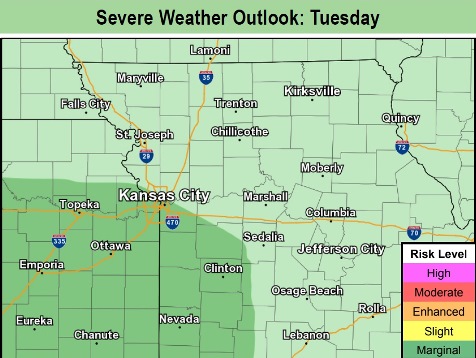
Tuesday, there is a 70 percent chance of showers and possibly a thunderstorm before 10 a.m., then showers are likely between 10 a.m. and 1 pm., then showers and a thunderstorm after 1 p.m., the weather service said. Some of the storms could produce heavy rain. The high will be near 64 with an east northeast wind of 8 to 10 mph. Between a tenth and quarter-inch of rain is possible.
Tuesday night, there is an 80 percent chance of showers and storms, with the possibility of heavy rain, according to the weather service. The low will be around 59 with an east wind of 8 to 10 mph. Between a half and three-quarters of an inch of rain is possible.
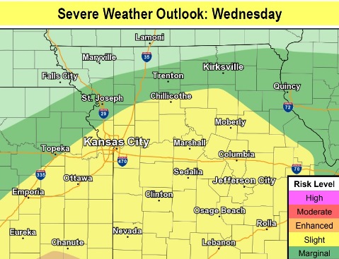
Wednesday, there is a 60 percent chance of showers and thunderstorms before 1 p.m., then more chances of rain and thunderstorms after 1 p.m., the weather service said. Some storms could be severe, with heavy rain. It will be cloudy, with a high near 73 and a south southwest wind of 10 to 13 mph, gusting as high as 23 mph. Between a quarter and half-inch of rain is possible.
Wednesday night, there is an 80 percent chance of showers and possibly a thunderstorm before 1 a.m., then a chance of showers and thunderstorms between 1 a.m. and 4 a.m., then a chance of showers after 4 a.m., according to the weather service. Some of the storms could be severe, with heavy rain. The low will be around 48, with new rainfall amounts of a quarter to a half-inch of rain.
Thursday, the high will be near 57 with mostly cloudy skies, the weather service said.
Thursday night, the low will be 45 with mostly cloudy skies, according to the weather service.
Friday, expect a high of 65 with mostly sunny skies, the weather service said.
Friday night, there will be partly cloudy skies with a low of 48, according to the weather service.
Saturday, the high will be near 68 with partly sunny skies, the weather service said.
Saturday night, the low will be around 50 with mostly cloudy skies, according to the weather service.
Sunday, it will be mostly sunny with a high near 69, the weather service said.