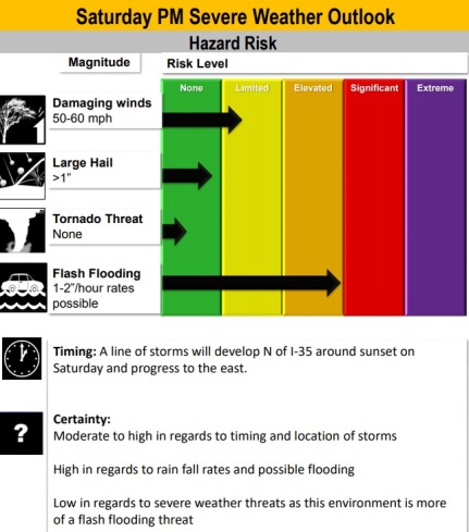
Severe weather and flash flooding will be possible Saturday night into the overnight hours, according to the National Weather Service.
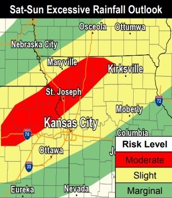
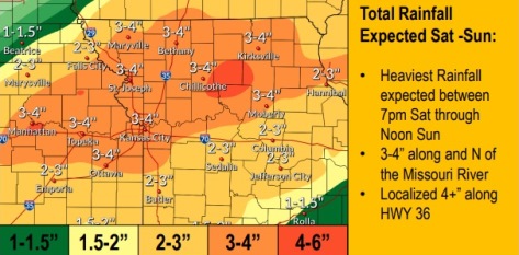
The main threat will be damaging winds, widespread moderate to heavy rainfall Saturday afternoon through Sunday afternoon, with 3 to 5 inches of rainfall possible, the weather service said.
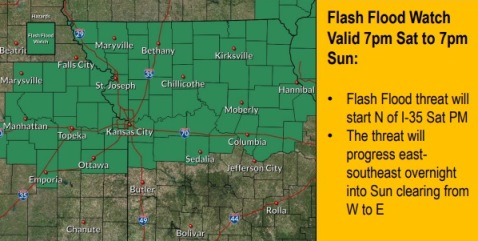
A flash flood watch will be in effect from 7 p.m. Saturday through 7 p.m. Sunday, according to the weather service.
The focus of the area of higher rainfall totals, more than 3 inches, has shifted slightly to the north of I-70, the weather service said.
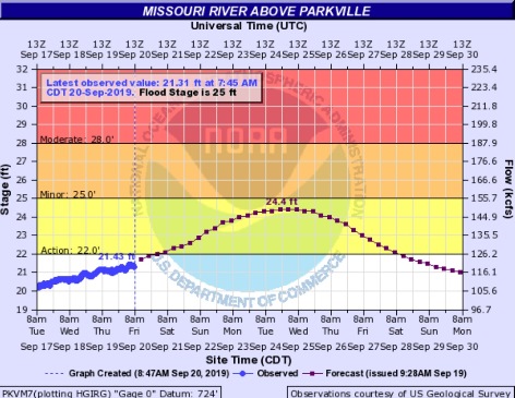
Missouri River flooding could be enhanced with local rainfall, the weather service said. The Missouri River at Parkville is currently below action stage and below flood stage, and could rise into action stage today, according to the weather service.
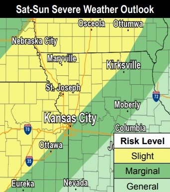
The line of storms is expected to develop north of I-35 around sunset on Saturday and progress to the east, according to the weather service. The event is expected to be more of a flash flooding event than a flooding event.
Today, there is a 40 percent chance of showers, then a chance of showers and thunderstorms after 1 p.m., the weather service said. A light south wind will increase to 5 to 10 mph in the morning. New rainfall amounts of less than a tenth of an inch are expected.
Tonight, there is a 60 percent chance of showers and thunderstorms, then showers are likely and possibly a thunderstorm after 4 a.m., according to the weather service. The low will be around 72 with a south wind of 7 to 9 mph. Less than a tenth of an inch of rain is expected.
Saturday, there is a 60 percent chance of showers and thunderstorms, mainly before 1 p.m., the weather service said. The high will be near 81 with a south wind of 10 to 14 mph, gusting as high as 18 mph. Between a quarter and half-inch of rain is possible.
Saturday night, there is an 80 percent chance of showers and thunderstorms, and some may produce heavy rainfall, according to the weather service. The low will be around 67 with a south wind of 6 to 10 mph. Between 1 and 2 inches of rain are possible.
Sunday, there is a 70 percent chance of showers and thunderstorms, mainly before 1 p.m., the weather service said. It will be cloudy through mid-morning, then gradually clearing, with a high near 75. Light and variable winds will change to north northwest around 6 mph in the morning. Between 1 and 2 inches of rain are possible.
Sunday night, it will be mostly clear with a low of 57, according to the weather service.
Monday, it will be sunny with a high near 80, the weather service said.
Monday night, it will be partly cloudy, with a low of 62, according to the weather service.
Tuesday, there is a 30 percent chance of showers and thunderstorms, with a high near 77, the weather service said.
Tuesday night, there is a 40 percent chance of showers and thunderstorms, with a low of 66, according to the weather service.
Wednesday, it will be partly sunny with a high near 82, the weather service said.
Wednesday night, there is a 30 percent chance of showers and thunderstorms, with a low of 64, according to the weather service.
Thursday, it will be partly sunny with a high near 77, the weather service said.
For more information, visit www.weather.gov.