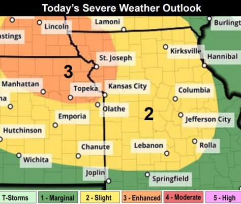
A cluster of storms is likely to move into the region Tuesday evening and continue into the overnight hours Tuesday night into Wednesday morning, according to the National Weather Service.
Severe storms are expected, with damaging wind gusts and large hail the primary hazards, the weather service said. An isolated tornado cannot be ruled out, according to the weather service.
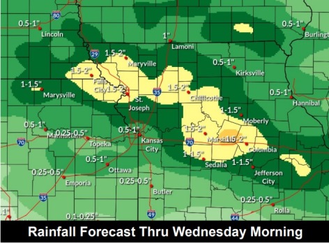
Locally moderate to heavy rainfall will be possible which may lead to localized flash flooding as well as minor river flooding, the weather service said. Hydrology charts from National Oceanic and Atmospheric Administration (NOAA) and U.S. Geological Survey (USGS) on Tuesday morning showed all the rivers in Wyandotte County were not anywhere near flooding levels.
Thunderstorms tonight could produce a half-inch to an inch or more of rain. Local flash flooding is possible, and minor river flooding also is possible, according to the weather service.
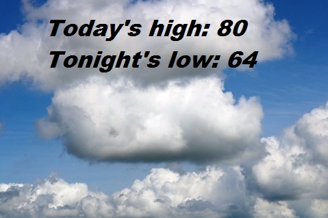
Today, there is 30 percent chance of showers and thunderstorms, mainly after 4 p.m., the weather service said. The high will be near 80 with a south wind of 8 to 10 mph, gusting as high as 21 mph. Less than a tenth of an inch of rain is possible.
Tonight, there is an 80 percent chance of showers and thunderstorms before 4 a.m., then showers are likely and possibly a thunderstorm between 4 a.m. and 5 a.m., followed by a chance of showers and thunderstorms after 5 a.m., according to the weather service. The low will be around 64 with a south southeast wind of 6 to 10 mph becoming west southwest after midnight. Winds may gust up to 20 mph. Between a half and three-quarters of an inch of rain is possible.
Wednesday, there is a 10 percent chance of showers and thunderstorms before 7 a.m., with a high near 80,the weather service said. A light and variable wind will become north northwest 5 to 8 mph in the morning.
Wednesday night, it will be mostly clear, with a low of 60, according to the weather service. A north northwest wind of 6 mph will become calm in the evening.
Thursday, it will be sunny, with a high near 88, the weather service said. A light southeast wind will become south 8 to 13 mph in the morning. Winds may gust as high as 22 mph.
Thursday night, there is a 30 percent chance of showers and thunderstorms, with a low of 67, according to the weather service. Less than a tenth of an inch of rain is predicted.
Friday, it will be mostly sunny, with a high near 77, the weather service said.
Friday night, there is a 40 percent chance of showers, with a low of 51, according to the weather service.
Saturday, there is a 30 percent chance of showers before 1 p.m., with a high near 62, the weather service said.
Saturday night, it will be partly cloudy, with a low of 45, according to the weather service.
Sunday, it will be sunny, with a high near 69, the weather service said.
Sunday night, it will be mostly cloudy, with a low of 51, according to the weather service.
Monday, there is a 30 percent chance of showers, with a high near 70, the weather service said.
For more weather information, visit www.weather.gov.