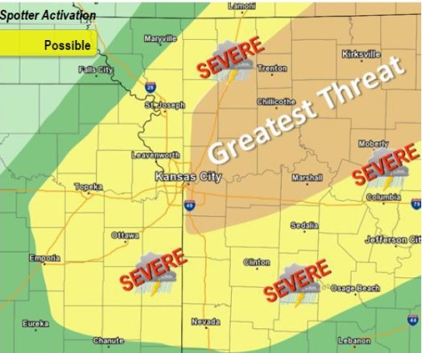
Severe thunderstorms are possible this afternoon and evening across much of the area, according to the National Weather Service.
Areas north of Kansas City may see a few thunderstorms this morning before this activity pushes northeast out of the area, the weather service said.
A second round of thunderstorms may redevelop this afternoon along and ahead of a cold front, and push through much of the area, according to the weather service.
As storms evolve, a line of thunderstorms may form as they move southeast with the main threat becoming damaging winds, the weather service said.
For Wyandotte County, there is a 60 percent chance of showers and thunderstorms, mainly after 2 p.m. Saturday, the weather service said. Today’s high will be near 79 with a light south southwest wind increasing to 8 to 13 mph in the morning. Between a quarter and half-inch of rain is possible.
Tonight, there is an 80 percent chance of showers and thunderstorms before 1 a.m., then a chance of showers, according to the weather service. The low will be around 47, with a southwest wind of 16 mph becoming north northwest after midnight. Winds may gust as high as 23 mph. Between a tenth and a quarter-inch of rain is possible.
Sunday, it will be sunny with a high near 61, and a north northwest wind of 9 to 13 mph, the weather service said.
Sunday night, it will be clear with a low of 41, and a northwest wind of 5 mph becoming calm in the evening, according to the weather service.