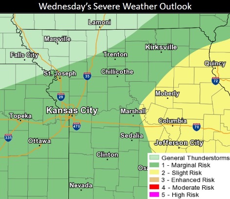
A slight chance of scattered showers and storms is possible this afternoon and evening, according to the National Weather Service.
The chance of showers and storms is 20 percent this afternoon and 40 percent tonight, the weather service said.
Possible hazards with these storms are quarter to ping pong ball-size hail, 50 to 70 mph wind gusts and an isolated tornado risk in some areas, according to the weather service.
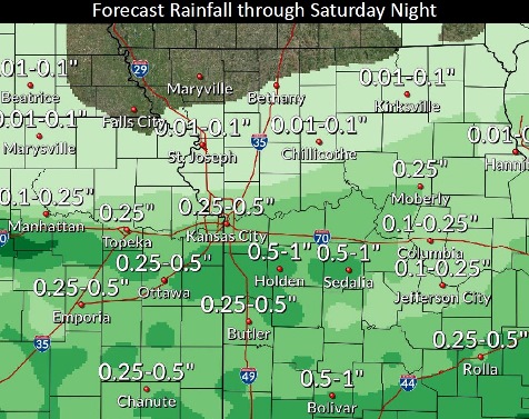
Flash flooding is possible with any rainfall today through the late week and weekend, the weather service said.
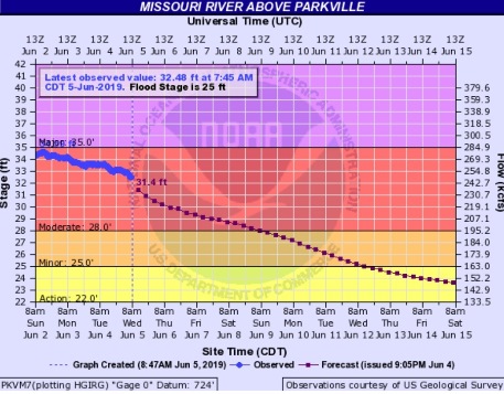
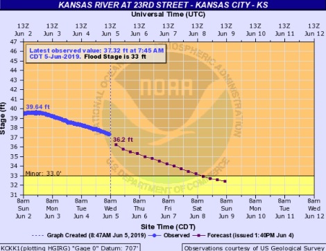
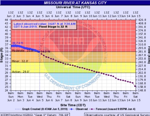
Major river flooding continues today on the Missouri River. In Wyandotte County, the Missouri River at Parkville is in moderate flood stage and the Kansas River is in minor flood stage. Both river levels are declining. Some roads in the region are impassable because of flooding, and drivers are asked to use caution.
Today, there is a 20 percent chance of showers and thunderstorms after 4 p.m., the weather service said. The high will be near 89 with a southwest wind of 5 mph becoming calm in the morning.
Tonight, there is a 40 percent chance of showers and thunderstorms, low a low of 67 and a calm wind, according to the weather service.
Thursday, there is a 50 percent chance of showers and thunderstorms, with a high near 85, the weather service said. Less than a tenth of an inch of rain is expected.
Thursday night, there is a 30 percent chance of showers and thunderstorms, with a low of 66, according to the weather service. The low will be around 66 with a calm wind. Less than a tenth of an inch of rain is expected.
Friday, there is a 30 percent chance of showers and thunderstorms, with a low of 66 and a calm wind, the weather service said. The high will be near 82 with a light east wind. Less than a tenth of an inch of rain is expected.
Friday night, there is a 20 percent chance of showers and thunderstorms, with a low of 65, according to the weather service.
Saturday, there is a 40 percent chance of showers and thunderstorms, with a high near 80, the weather service said.
Saturday night, the low will be around 65 with mostly cloudy skies, according to the weather service.
Sunday, it will be partly sunny, with a high near 81, the weather service said.
Sunday night, it will be partly cloudy with a low of 59, according to the weather service.
Monday, it will be sunny with a high near 77, the weather service said.
Monday night, it will be partly cloudy, with a low of 57, according to the weather service.
Tuesday, it will be mostly sunny with a high near 77, the weather service said.
For more weather information, see www.weather.gov.