Rains that could hit the Midwest this weekend could cause small tributaries to rise above flood stage in the next few days, according to a National Weather Service forecaster.
In a news conference Friday, forecasters said the rise of the Missouri River over the next few days from rains that had already taken place will be 1 to 2 feet from St. Joseph, Missouri, to the mouth of the river.
With widespread heavy rain in the forecast for this weekend, additional creeks and streams are expected to rise above flooding, according to forecasters, with a 1 to 2 foot increase possible on top of the earlier increase, if the rain materializes.
At this time, the rivers here are not expected to rise above their highest levels in March and May.
Corps of Engineers officials said releases from Gavins Point dam in South Dakota will be decreased from 75,000 cfs to 70,000 cfs next week and conditions will be assessed daily.
The lower Kansas basin and the Osage basin reservoirs have seen improvement in the past week, according to Corps of Engineers officials.
While the reservoirs are 7 percent lower than last week, a single rainfall could still push some of them into surcharge operations, according to officials.
Tuttle Creek was releasing 10,000 cfs on Friday, with Milford at 5,000 cfs and Perry at 1,000 cfs, officials said. Officials expected those amounts to remain steady, and they are monitoring conditions on the Missouri River.
In the Osage basin, Truman dam was releasing 50,000 cfs on Friday with a forecast to maintain that amount. Melvern was increasing from 1,500 cfs on Friday to 3,000 cfs on Saturday. Pomona was at 1,500 cfs, while Hillsdale remained at 2,800 cfs. Stockton and Pomme de Terre were at 3,000 cfs.
This has been the largest flooding rehabilitation effort in the Kansas City district since 1993, according to officials.
Corps officials said they had 79 requests for levee rehabilitation since March, and that could easily rise to 90.
According to Corps officials, the peak river level at Kansas City was on June 2 at 305,000 cfs. The amount of regulated releases in that amount was 105,000 cfs, with 200,000 unregulated rain that fell on the basin and made its way to that point. Sixty-five percent of the water coming through the Missouri River on June 2 was from unregulated rainfall, officials said.
For St. Joseph, Missouri, the peak was May 30 at 210,000 cfs. About 30 percent of that peak was regulated waters coming from reservoirs upstream, while 70 percent of the water was rainfall that fell in the basin and was unregulated, according to Corps officials.
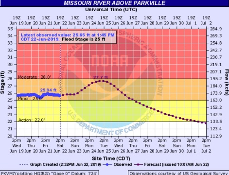
In Wyandotte County, the Missouri River at Parkville, which includes Wyandotte County in its area, is currently in minor flood stage, well below its peak levels this spring. The river was at 25.65 feet at 1:45 p.m. Saturday, and hydrology charts predicted that it would rise to 27.7 feet on Monday evening or Tuesday morning. The gauge is on I-435 over the Missouri River, between Wyandotte and Platte counties.
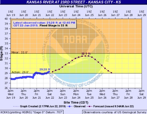
The Kansas River at 23rd Street, where the gauge is at Kansas Avenue and the state line, was at 29.28 feet in action stage at 12:45 p.m. Saturday, and was expected to rise to 32.5 feet by Monday evening or Tuesday. The level is below minor flood stage.