Look for rain and storms in today’s forecast, between 2 p.m. and 5 p.m., in advance of a cold front moving into the area.
Some showers are possible this afternoon, according to the National Weather Service.
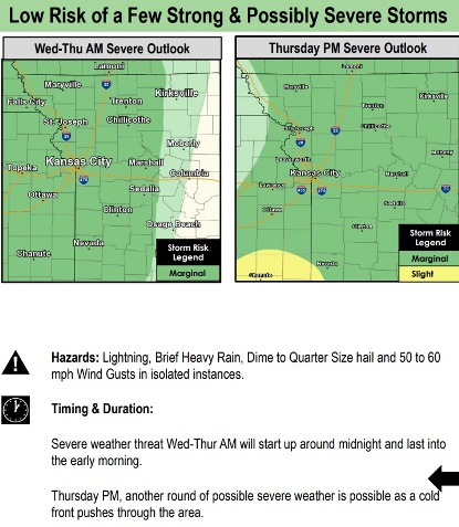
The weather service said a strong cold front will arrive Thursday and Friday, and will bring with it thunderstorms, gusty winds and much cooler temperatures.
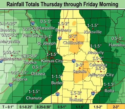
From a half-inch to 2.5 inches of rain is possible on Thursday to Friday morning, according to the weather service.
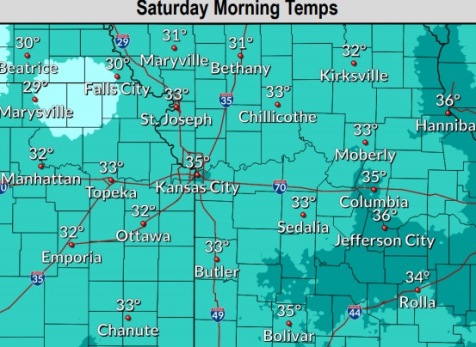
Some areas north of Kansas City will experience their first freezing temperatures of the season on Saturday morning, the weather service said.
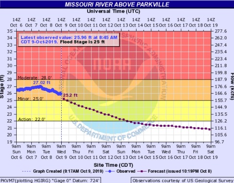
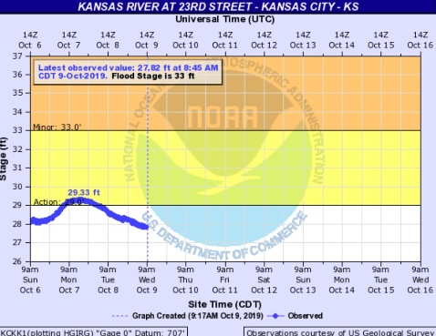
The Missouri River at Parkville, where the gauge is on I-435 between Wyandotte and Platte counties, continues in minor flood stage, according to hydrology charts. The Kansas River at 23rd Street, where the gauge is near Kansas Avenue and the state line, is below flood stage and below action stage.
Today, showers are likely, mainly between 2 p.m. and 5 p.m., the weather service said. The high will be near 67 with a south wind of 9 mph, gusting as high as 24 mph. There is a 60 percent chance of rain, with less than a tenth of an inch expected.
Tonight, there is a 70 percent chance of showers before 10 p.m., then a slight chance of showers and thunderstorms between 10 p.m. and 1 a.m., then showers likely and possibly a thunderstorm after 1 a.m., according to the weather service. The low will be around 59 with a south southeast wind of 8 mph, gusting as high as 25 mph. Between a tenth and quarter-inch of rain is possible.
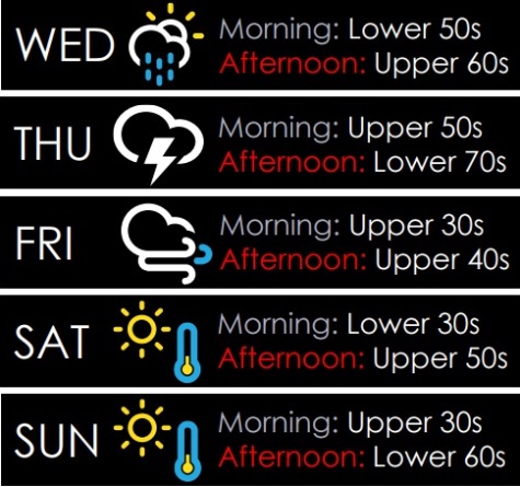
Thursday, there is an 80 percent chance of showers and possibly a thunderstorm before 10 a.m., then showers are likely between 10 a.m. and 1 p.m., then showers and possibly a thunderstorm after 1 p.m., the weather service said. Patchy fog is possible between 10 a.m. and 11 a.m. The high will be near 74 with a south wind of 8 to 10 mph, gusting to 28 mph. Between a tenth and quarter-inch of rain is forecast.
Thursday night, there is a 50 percent chance of showers and thunderstorms before 1 a.m., then a chance of showers between 1 a.m. and 4 a.m., then a chance of rain after 4 a.m., according to the weather service. The low will be around 39 with a northwest wind of 11 to 13 mph, gusting to 25 mph. Between a quarter and half-inch of rain is expected.
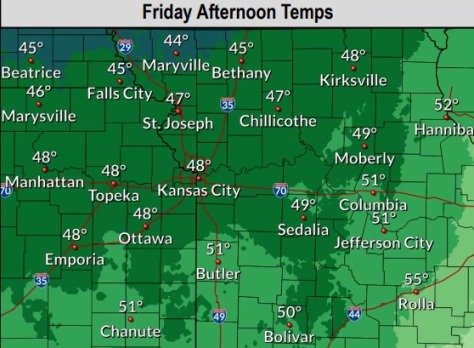
Friday, there is a 30 percent chance of rain before 10 a.m., then a slight chance of showers between 10 a.m. and 1 p.m., the weather service said. The high will be near 48 with a west northwest wind of 11 to 16 mph, gusting as high as 26 mph. Between a tenth and quarter-inch of rain is possible.
Friday night, the low will be around 33 with clear skies, according to the weather service.
Saturday, it will be sunny with a high near 59, the weather service said.
Saturday night, the low will be around 40, according to the weather service.
Sunday, the high will be near 62, with sunny skies, the weather service said.
Sunday night, it will be clear with a low of 40, according to the weather service.
Monday, Columbus Day, it will be sunny with a high near 66, the weather service said.
Monday night, it will be partly cloudy with a low of 47, according to the weather service.
Tuesday, it will be mostly sunny, with a high near 63, the weather service said.