A thunderstorm was moving into the Wyandotte County area about 8:30 a.m. Tuesday
According to the National Weather Service, between a tenth and a quarter of an inch of rain is possible today. After 11 a.m., it is expected to gradually become sunny, with a high near 86, the weather service said.
Today is the first time temperatures have been below the normal high since June 7, according to the weather service.
Tonight’s low will be 67 with a 20 percent chance of showers and storms, the weather service said.
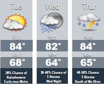
Wednesday, there is a 30 percent chance of showers and thunderstorms, mainly between 7 a.m. and 1 p.m., according to the weather service. The high will be near 83, with a southeast wind of 7 mph. Between a tenth and quarter-inch of rain is possible.
Wednesday night, there is a 40 percent chance of showers and thunderstorms, according to the weather service. The low will be around 68, with a southeast wind of 6 mph.
Thursday, expect a 50 percent chance of rain and storms, with a high near 84, the weather service said. There will be a southwest wind of 7 mph.
Thursday night, there is a 50 percent chance of showers and thunderstorms, according to the weather service. The low will be around 67. Between a half and three-quarters of an inch of rain are possible.
Friday, there is a 30 percent chance of showers and storms, with a high near 82, the weather service said.
The forecast for Independence Day, Monday, July 4, is mostly sunny with a high near 89, according to the weather service.