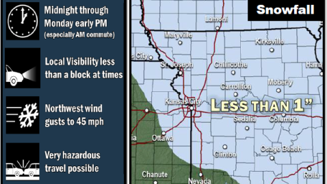
Scattered rain and snow showers are possible Sunday evening before midnight, then scattered snow showers are possible after midnight, according to the National Weather Service.
Tonight’s low will be 28. The west northwest wind will be from 16 to 24 mph with gusts as high as 34 mph, according to the weather service. There is a 50 percent chance of precipitation.
Monday’s forecast calls of scattered snow showers, mainly before noon, then isolated flurries after 3 p.m., the weather service said. The high Monday will be near 31.
A wind advisory will be in effect from 8 a.m. to 6 p.m. Monday, the weather service said. The north northwest wind will be from 25 to 30 mph, gusting as high as 43 mph. The chance of precipitation is 50 percent.
The weather service said strong crosswinds on highways could make travel difficult, particularly for high-profile vehicles.
On Monday, the weather service said the winds could combine with snow showers to create brief but intense snow squalls, especially during the morning hours.
Visibility could be greatly reduced, and the combination of near-zero visibility and light snow accumulations on roadways could result in hazardous driving conditions, especially during the Monday morning commute, the weather service said.
Monday night, the low will be around 19, according to the weather service. It will be blustery, with a north northwest wind of 19 to 24 mph decreasing to 13 to 18 mph after midnight. Winds may gust as high as 32 mph.
Tuesday, it will be partly sunny with a high near 34, the weather service said. The north northwest wind will be 10 to 14 mph, with gusts as high as 20 mph.
Tuesday night, the low will be around 15, with a north northwest wind of 10 mph, according to the weather service.
For more information, visit www.weather.gov.