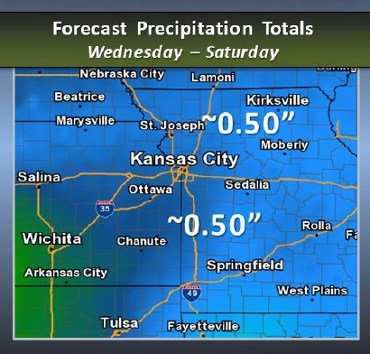
Periods of light precipitation are expected beginning Wednesday and lasting into Saturday, the National Weather Service said.
Average precipitation of one-half inch is anticipated through this period, according to forecasters.
Initial precipitation Wednesday morning may be light freezing drizzle, the weather service said.
Forecasters are uncertain to the coverage, intensity, and any potential effects to morning travel.
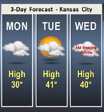
Today, there is a chance of flurries in the early morning, followed by cloudy skies with a high of 29, the weather service said. Tonight’s low will be around 22.
Tuesday, it will be mostly sunny with a high near 41, according to the weather service. Patchy freezing drizzle is possible after midnight, and the low will be around 29 Tuesday night.
Wednesday, there is a 30 percent chance of patchy snow and freezing drizzle before 9 a.m., then a chance of rain between 9 a.m. and noon, and possibly drizzle after noon. The high will be near 40.
Wednesday night, there is a 50 percent chance of rain, the weather service said. The low will be around 36.
Thursday, expect a 60 percent chance of rain, according to the weather service, with a high near 44. Thursday night, there is a 60 percent chance of rain with a low around 37.
Friday, there is a 40 percent chance of rain, with a high near 47, the weather service said. Friday night, there is a 30 percent chance of rain and snow with a low of 31, according to the weather service.
Saturday’s forecast is mostly cloudy with a high near 36, the weather service said. Saturday night, there will be a low around 18.
Sunday will be partly cloudy with a high near 27, according to the weather service.