Rain and severe storms are in today’s forecast from the National Weather Service.
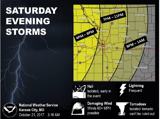
According to the weather service, storms are expected to develop around 4 to 6 p.m. today, forming a line. They could intensify toward 6 p.m. or later.
Individual storms may be capable of producing up to quarter-size hail, but the main threat will become damaging winds, the weather service said.
Some storms may produce winds greater than 60 mph, and an isolated tornado cannot be ruled out, according to the weather service.
Lightning and heavy rain are likely tonight, with Wyandotte County and Kansas City, Kansas, receiving 1 to 2 inches of rain, the forecast predicted.
Heavy rain could lead to minor river flooding and flash flooding in low-lying and flood-prone areas, the weather service said. Anyone on the road is advised to be cautious and not to try to cross flooded roads. Also, drivers should beware of hydroplaning, reduced visibility and wipers not keeping up with the rain rate, according to the weather service.
Today’s high will be near 74, with a south wind of 15 to 20 mph, gusting as high as 29 mph.
Tonight, expect a 100 percent chance of showers and thunderstorms before 10 p.m., then showers and possibly a thunderstorm between 10 p.m. and 1 a.m., then a chance of showers after 1 a.m., according to the weather service. The low will be around 50. The wind will be calm, changing to northwest 5 to 8 mph in the evening. Between 1 and 2 inches of rain are possible.
Sunday, it will be mostly sunny with a high of 67 and a northwest wind of 5 to 7 mph, the weather service said.
Residents are advised to keep up with the weather reports and warnings today through the website, www.weather.gov, through the media or through a weather radio.