Today, there will be a chance of rain and possibly a thunderstorm after 2 p.m., according to the National Weather Service.
Temperatures today, tonight and through the day Sunday will stay above freezing, the weather service said.
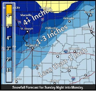
Cold air will move south Sunday night bringing the threat of snow or ice to areas north and west of I-35 Sunday night, according to the weather service.
Cold air, and the potential for snow, will then spread across the rest of eastern Kansas and northern Missouri Monday, the weather service said.
Highest wintry accumulations are expected to be across the far northwest corner of Missouri, east along the Iowa border with several inches of snow possible, according to the weather service.
The high today in Wyandotte County will be near 47, and there will be an east northeast wind of 6 to 15 mph, becoming north in the afternoon, and possibly gusting up to 22 mph, the weather service said.
Tonight, rain and possibly a thunderstorm is possible before midnight, and rain afterwards, according to the weather service. Tonight’s low will be around 33 in Wyandotte County.
Winds may be 17 to 21 mph from the north, with gusts as high as 29 mph, the weather service said.
Sunday, temperatures will drop, according to the weather service. The high will be near 34 with a 50 percent chance of precipitation. A north northeast wind will be from 17 to 21 mph, with gusts as high as 29 mph.
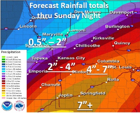
Sunday night, there is an 80 percent chance of rain with a low around 33, the weather service said. A northeast wind of 23 to 26 mph may gust as high as 36 mph. Between three quarters and one inch of rain is possible.
On Monday, rain, snow showers and sleet, becoming all snow after noon, is possible, the weather service said. There is a 90 percent chance of precipitation. The high will be near 34. A northeast wind of 20 to 25 mph will beome north from 9 to 14 mph in the afternoon. Winds may gust as high as 34 mph.
Monday night, there is a 30 percent chance of snow, according to the weather service. The low will be around 24.
Tuesday, it will be partly sunny with a high near 29, the weather service said. On Tuesday night, the low will be around 19, according to the weather service.
Wednesday, expect mostly cloudy skies with a high near 29, the weather service said. Wednesday night’s forecast is partly cloudy with a low of 16.
Thursday, it will be mostly sunny, with a high near 30, according to the weather service.
Thursday night, New Year’s Eve, it will be partly cloudy with a low around 18, the weather service said.
Friday, New Year’s Day, it will be partly sunny with a high near 30, the weather service said.