
Today, rain is possible, according to the National Weather Service.
A revised forecast showed one-tenth to one-quarter of an inch of rain for Wyandotte County through Saturday, with higher amounts to the west, in Manhattan, Kansas, and Emporia, Kansas, the weather service said. Those areas could see 3 inches of rain or more. Wyandotte County could be close to the dividing line for heavy rain and lighter amounts of rain.
According to the weather service, if the heavy rain axis moves east even a short distance, portions of this area could be subject to higher amounts of rain.
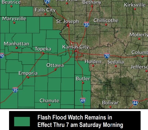
Wyandotte County is still in the flash flood watch area, where the weather service says 1 to 2 inches of rain are possible.
The rivers in Wyandotte County are currently below flood stage and below action stage. The Missouri River at Parkville, which includes Wyandotte County at I-435 over the Missouri River, went below action stage, 22 feet, in the past few days. Flood stage is 25 feet. The Kansas River at 23rd Street, where the gauge is near Kansas Avenue and the state line, was at 27.28 feet on Friday morning, where action stage is 29 feet. Flood stage is 33 feet.
Today, there is a 70 percent chance of showers and thunderstorms, with the possibility of heavy rain. The high will be near 79 with an east southeast wind of 6 to 8 mph. Between a tenth and quarter-inch of rain is possible.
Tonight, there is a 50 percent chance of showers and thunderstorms, and some may produce heavy rain. The low will be around 67 with an east wind of 5 to 9 mph becoming calm after midnight. Less than a tenth of an inch of rain is possible.
Saturday, there is a 40 percent chance of showers and thunderstorms, mainly before 1 p.m., the weather service said. The high will be near 82 with an east wind of 6 to 11 mph. Less than a tenth of an inch of rain is possible.
Saturday night, it will be partly cloudy, with a low of 66, according to the weather service. There will be an east northeast wind of 5 to 8 mph.
Sunday, it will be sunny with a high near 86 and a light northeast wind, the weather service.
Sunday night, it will be mostly clear with a low of 65, according to the weather service.
Monday, it will be sunny with a high near 87, the weather service said.
Monday night, it will be partly cloudy with a low of 69, according to the weather service.
Tuesday, it will be partly sunny with a high near 86, the weather service said.
Tuesday night, it will be partly cloudy, with a low of 68, according to the weather service.
Wednesday, it will be mostly sunny, with a high near 86, the weather service said.
Wednesday night, it will be partly cloudy, with a low of 67, according to the weather service.
Thursday, it will be partly sunny with a high near 85, the weather service said.
For more information, visit www.weather.gov.