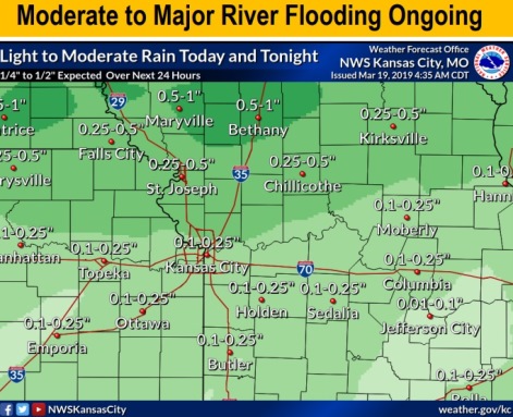
Light to moderate rain is expected Tuesday along the Missouri River Basin, including in Wyandotte County, according to the National Weather Service.
This precipitation along with water from levee breaches and overtoppings re-entering the river upstream may aggravate already swollen and flooding rivers and streams, the weather service said.
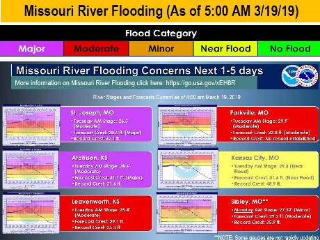
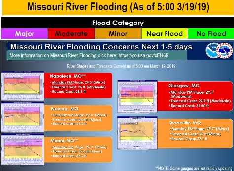
Many rivers are still in flood or are continuing to rise, according to the weather service, with moderate to major river flooding over the region. Several forecast points along the Missouri River are expected to reach moderate to major flood status and break previous record crests, the weather service said.
The flooding is caused by the recent rainfall, snow melt and water releases upstream flowing into the Missouri River Basin and creating flooding along the Missouri River. Future forecasts will depend on rainfall, snow melt, water re-entering the river from levee breaches and any increase in upstream water releases, the weather service said.
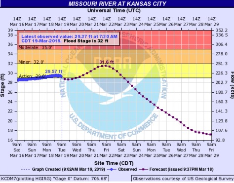
The Missouri River at Kansas City is in action stage at 29.37 feet and is expected to crest on Friday at 31.6 feet, where minor flood stage is 32 feet, according to hydrology charts.
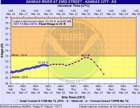
The Kansas River at 23rd Street in Kansas City, Kansas, is currently in action stage at 31.18 feet and is expected to crest at 32.7 feet on Friday, where flood stage is 33 feet.
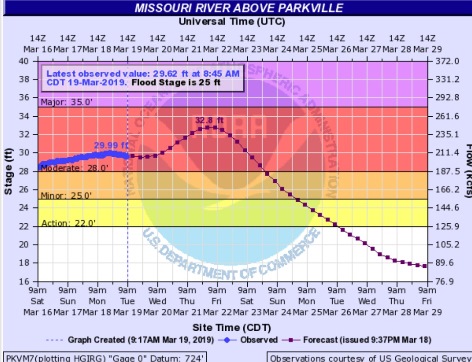
The Missouri River at Parkville, Missouri, which is across the river from Kansas City, Kansas, is currently in moderate flood stage at 29.62 feet, where flood stage is 25 feet, according to hydrology charts. It is expected to crest at 32.8 feet on Friday.
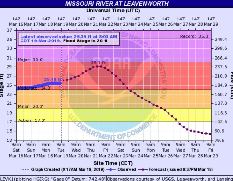
Many places upstream, including Leavenworth, Kansas, Atchison, Kansas, and St. Joseph, Missouri, are in moderate flood stage currently. Atchison is expected to go into major flood stage on Thursday, according to hydrology charts. St. Joseph also is projected to go into major flood stage later today, cresting on Thursday. At this time, Leavenworth is not forecast to go into major flood stage, and is expected to crest on Thursday and Friday.
Today’s weather for Wyandotte County includes a 30 percent chance of showers before 1 p.m., then a slight chance of rain after 4 p.m., the weather service said. The high will be near 57 with an east southeast wind of 7 to 11 mph. Less than a tenth of an inch of rain is predicted during the daytime.
Tonight, there is a 70 percent chance of rain, mainly before 11 p.m., according to the weather service. The low will be around 38 with an east southeast wind of 6 to 11 mph becoming light and variable. Between a tenth and quarter-inch of rain is possible.
Wednesday, it will be mostly cloudy through mid-morning, then gradually clearing, with a high near 55, the weather service said. A west wind of 5 to 14 mph will gust as high as 20 mph.
Wednesday night, it will be mostly clear, with a low of 33, and a north northwest wind of 7 mph, according to the weather service.
Thursday, it will be sunny with a high near 56 and a north northwest wind of 7 mph, the weather service said.
Thursday night, it will be clear, with a low of 35, according to the weather service.
Friday, it will be sunny, with a high near 63, the weather service said.
Friday night, it will be partly cloudy with a low of 41, according to the weather service.
Saturday, there is a 40 percent chance of rain after 1 p.m., with a high near 63, the weather service said.
Saturday night, there is a 40 percent chance of rain with a low of 47, according to the weather service.
Sunday, there is a 60 percent chance of rain, with a high near 62, the weather service said.
Sunday night, there is a 50 percent chance of rain, with a low of 49, according to the weather service.
Monday, there is a 60 percent chance of rain, with a high near 62, the weather service said.
For more information, visit www.weather.gov.