Rain is in today’s forecast, continuing through the weekend, according to the National Weather Service.
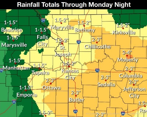
From 1.5 to 2 inches of rain are expected from Thursday through Monday night, the weather service said. This may lead to localized flooding.
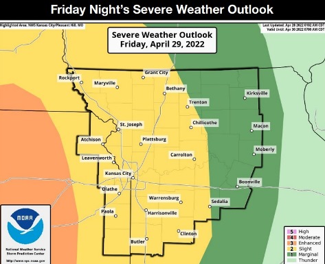
Also, severe storms are possible Friday night, according to the weather service.
Severe weather, including damaging winds, large hail and tornadoes, are possible in the region Friday night into Saturday morning, the weather service said.
Flash and river flooding are possible with heavy rain on top of rounds of rain from previous days, according to the weather service.
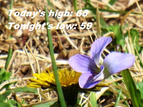
Today, the scattered storms and showers will most likely be worse along and south of I-70, the weather service said. There is a 50 percent chance of showers and thunderstorms, with a high near 68. A south wind of 7 to 14 mph will gust as high as 22 mph. Less than a tenth of an inch of rain is in the forecast.
Tonight, there is an 80 percent chance of showers and thunderstorms, then showers and possibly a thunderstorm after 4 a.m., according to the weather service. The low will be around 59 with a southeast wind of 9 to 11 mph, gusting as high as 24 mph. Between a quarter and half-inch of rain is possible.
Friday, there is an 80 percent chance of showers and possibly a thunderstorm before 7 a.m., then a chance of showers and thunderstorms, mainly between 7 a.m. and 1 p.m., the weather service said. The high will be near 75, with a south southeast wind of 9 to 10 mph, gusting to 32 mph. Less than a tenth of an inch is possible.
Friday night, there is an 80 percent chance of showers and possibly a thunderstorm before 1 a.m., then a chance of showers and thunderstorms after 1 a.m., according to the weather service. The low will be around 57 with a south southeast wind of 10 to 16 mph, gusting as high as 32 mph. Between a half and three-quarters of an inch of rain is possible.
Saturday, there is a slight, 10 percent, chance of thunderstorms before 7 a.m., with a high near 66, the weather service said. A west southwest wind of 10 to 18 mph will gust as high as 31 mph.
Saturday night, it will be mostly cloudy, with a low of 47, according to the weather service.
Sunday, it will be mostly sunny, with a high near 64, the weather service said.
Sunday night, it will be partly cloudy, with a low of 46, according to the weather service.
Monday, there is an 80 percent chance of showers, with a possible thunderstorm after 1 p.m., the weather service said. The high will be near 65.
Monday night, there is a 50 percent chance of showers before 1 a.m., with a low of 47, according to the weather service.
Tuesday, it will be mostly sunny, with a high near 71, the weather service said.
Tuesday night, there is a 40 percent chance of showers, with a low of 54, according to the weather service.
Wednesday, there is a 60 percent chance of showers, with a high near 69, the weather service said.