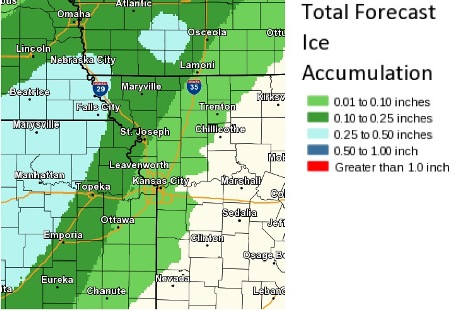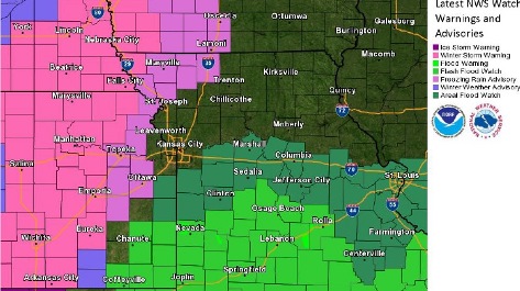
Winter storm warnings are in effect for much of central Kansas into far northwest Missouri where significant ice amounts could cause tree damage, power outages and travel problems, the National Weather Service said.
A freezing rain advisory is in effect further east and may mainly affect travel, the weather service said.
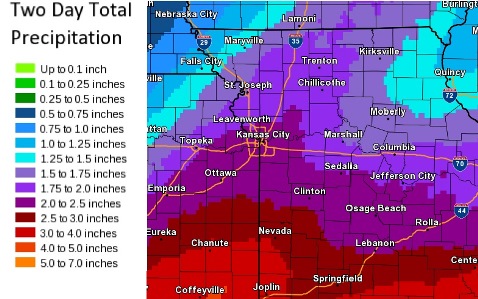
Meanwhile, flood and flash flood watches are in effect for the southern half of Missouri into eastern Kansas where 2 inches to 4 inches of rain could cause several rivers to flood, according to the weather service.
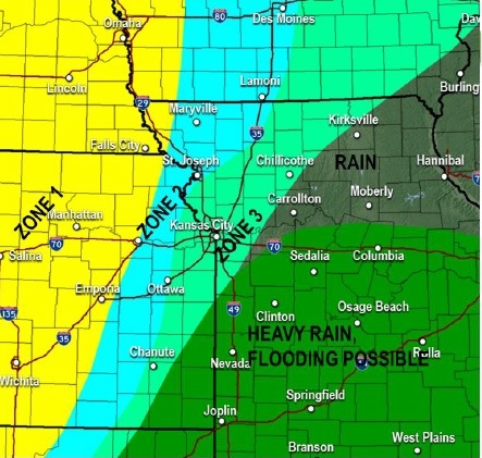
The weather service said that heavy rain and flooding is possible south of I-70 today and tonight.
Rain may change to freezing rain across areas near and west of I-35 this evening and tonight, according to the weather service.
With temperatures near freezing after midnight, into most of Friday, the rain today could change to freezing rain overnight, ending Friday afternoon, according to the weather service.
Minor icing will be possible, especially on elevated surfaces, the weather service.
Temperatures were 63 degrees at 10 a.m. Thursday, and will fall to around 42 by 5 p.m., according to the weather service.
A south wind of 9 to 15 mph will become north in the afternoon, gusting as high as 21 mph. Between 1 and 2 inches of rain is possible today, the weather service said.
Tonight, rain will continue, mainly before 3 a.m., according to the weather service. The low will be around 32. A north wind of 13 to 17 will gust as high as 25 mph. Between three-quarters and 1 inch of rain is possible.
Friday, rain or freezing rain is likely, mainly before noon, the weather service said. The high will be near 33. A north wind of 15 to 17 mph will gust as high as 25 mph. Little or no ice accumulation is expected.
Friday night, expect rain or freezing rain before 9 p.m., then areas of freezing drizzle, according to the weather service. The low will be around 28. A north northeast wind of 11 to 15 mph will gust as high as 22 mph. Less than a tenth of an inch of precipitation is expected.
A 30 percent chance of rain or freezing rain before noon is in Saturday’s forecast, the weather service said. It will be cloudy with a high of 34. A north northeast wind of 8 to 10 mph is predicted.
Saturday night, there will be a 40 percent chance of rain before midnight, then a chance of rain or freezing rain, according to the weather service. The low will be around 31.
Sunday, it will be mostly cloudy with a high near 41, the weather service said.
For more weather information, visit www.weather.gov.