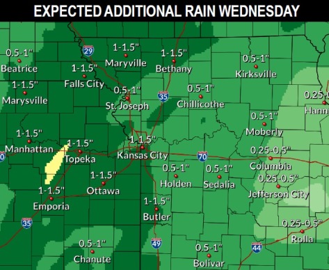
After some rain Wednesday morning, there is a possibility for more rain on Wednesday afternoon and night, according to the National Weather Service.
Rain could continue before 7 a.m. on Thursday, according to the forecast.
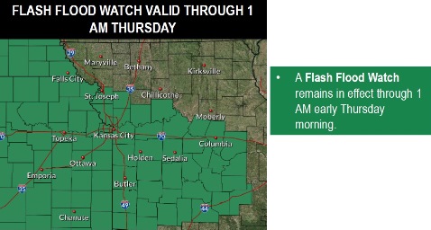
With an additional 1 to 2 inches of rain in the forecast, a flash flood watch continues for Wyandotte County through 1 a.m. Thursday, May 9, the weather service said. Local streams may flood and motorists are advised to avoid flooded roadways.
Thunderstorms today may not be as severe as originally expected. Most of Thursday, Friday, Saturday and Sunday will be dry, with a 20 percent chance of rain on Friday night.
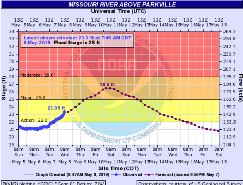
A flood warning will be in effect from Thursday afternoon to Tuesday, May 14, for the Missouri River at Parkville, which includes Wyandotte County, according to the weather service. Minor flooding is forecast. The river may rise above flood stage, 25 feet, by Thursday afternoon and may continue to rise to near 26.5 feet by early Saturday morning, then fall below flood stage by early Monday morning.
Today, there is a 50 percent chance of showers and thunderstorms before 3 p.m., with a high near 71 and a south wind of 11 to 13 mph, the weather service said. Between a quarter and half-inch of rain is possible.
Tonight, there is an 80 percent chance of showers and thunderstorms before 2 a.m., then a chance of showers, according to the weather service. The low will be around 45 with a light and variable wind becoming north northwest 9 to 14 mph after midnight, and gusting as high as 20 mph. Between a quarter and half-inch of rain is possible.
Thursday, there is a 20 percent chance of showers before 7 a.m., with a high near 53 and a north northwest wind of 11 to 14 mph, gusting as high as 18 mph, the weather service said.
Thursday night, it will be cloudy during the early evening, then gradually clearing, with a low of 43 and a north northwest wind of 6 to 11 mph, gusting as high as 18 mph, according to the weather service.
Friday, it will be mostly sunny with a high near 63 and a north wind of 6 to 8 mph, the weather service said.
Friday night, there is a 20 percent chance of showers after 2 a.m., with a low of 48, according to the weather service.
Saturday, it will be mostly cloudy, with a high of 65, the weather service said.
Saturday night, it will be mostly cloudy with a low of 50, according to the weather services.
Sunday, it will be sunny with a high near 70, the weather service said.
Sunday night, it will be mostly clear, with a low around 50, according to the weather service.
Monday, it will be sunny, with a high near 75, the weather service said.
Monday night, it will be mostly clear, with a low of 56, according to the weather service.
Tuesday, it will be mostly sunny, with a high near 78, the weather service said.