Scattered showers will dot the region this morning, though clearing skies remove any chance of rain by this afternoon, according to the National Weather Service.
Minor flooding is possible persisting along local rivers and streams in some areas due to the prolonged rain, the weather service said. The major rivers in Wyandotte County are currently not high, and are far from flood stage.
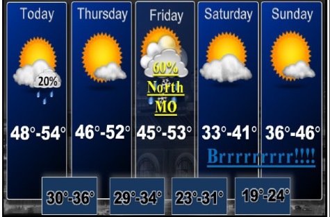
There is a chance for some light snow Friday night and Saturday morning across far northern Missouri; near the Iowa border, according to the weather service. At this time little accumulation (less than an inch) is anticipated.
Today, there is a 20 percent chance of showers before 11 a.m. The skies will be cloudy, becoming mostly sunny, with a high near 51, according to the weather service. A west southwest wind of 11 to 18 mph will gust as high as 29 mph.
Tonight, the low will be around 33. There will be a west wind of 8 to 10 mph, with gusts as high as 18 mph, the weather service said.
Thursday, skies will be mostly cloudy, then clearing, with a low around 33, according to the weather service. There will be a west wind of 8 to 10 mph, with gusts as high as 18 mph.
Thursday night, the low will be about 34, the weather service said. A west southwest wind of 5 to 7 mph will become light and variable.
On Friday, there will be a 40 percent chance of rain after noon, according to the weather service. The high will be 49. A south southeast wind of 6 to 9 mph will become north northeast in the afternoon.
Friday night, there is a 40 percent chance of rain before midnight, then a chance of snow, the weather service said. The low will be around 28.
Saturday’s forecast is sunny with a high of 39, according to the weather service. Saturday night, there will be a low of 24.
On Sunday, expect mostly sunny skies with a high of 44, the weather service said. Sunday night, the low will be around 32.