With the potential for inclement weather increasing, Waste Management will start collecting residential trash and recycling at 5 a.m.on Thursday, Dec. 22, in Kansas City, Kansas.
The early start is meant to keep drivers safe and collect as much as possible before weather conditions become prohibitive, according to information from the Unified Government.
Residents are encouraged to put their trash and recycling at the curb or street edge before 5 a.m. Thursday. Items may be placed at the curb or street edge as early as 4 p.m. on Wednesday, Dec. 21.
To help Waste Management collect routes more quickly, please avoid placing bulky items at the curb this week. Please also place trash and recycling at opposite ends of your driveway or walkway when possible. Separating these items helps drivers quickly assess the difference between what is trash and what is recycling.
Depending on the severity of the upcoming storm, residential trash and recycling collection may experience further disruption later this week. There will be updates on the Unified Government’s Facebook, Nextdoor, and website.
To learn more about Solid Waste Management, read frequently asked questions, and view helpful tips, visit wycokck.org/Waste. To report a service issue, call 3-1-1 or visit mywyco.wycokck.org.
The Kansas City, Kansas, Board of Public Utilities will meet at 6 p.m. Wednesday, Dec. 21.
On the agenda are a public comment time; general manager and staff reports, budget transfer consideration, resolution adopting the 2023 budget, miscellaneous comments and board comments.
The BPU’s administrative offices are at 540 Minnesota Ave., Kansas City, Kansas.
The public may access the meeting through the telephone or through a Zoom meeting.
To connect to the Zoom meeting, visit https://us02web.zoom.us/j/84523139724.
To connect by telephone, call toll free 1-888-475-4499.
The meeting ID number is 845 2313 9724.
To access the board meeting information packet, visit https://www.bpu.com/Portals/0/pdf/board-information-packet-12-21-22.pdf.
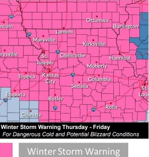
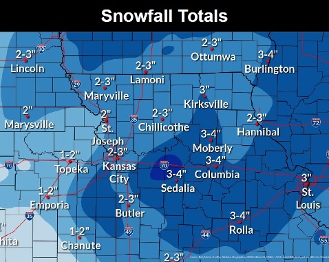
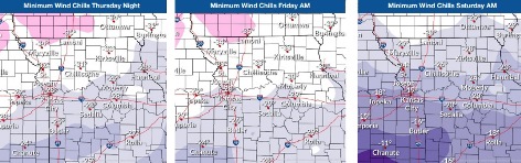
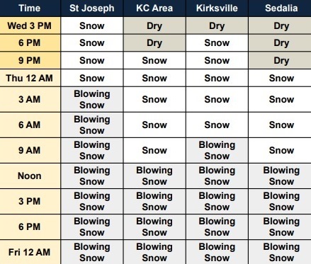
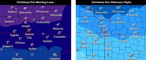
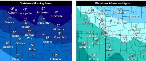
Snow is in the forecast for Wyandotte County, with 2 to 4 inches possible Thursday through Friday. (File photo)A winter storm warning is in effect from midnight Thursday through midnight Friday. (National weather Service graphic)From 2 to 4 inches of snow are possible in the area. (National Weather Service graphic)Dangerously cold temperatures move in on Thursday. (National Weather Service graphic)Projected timeline of the snowstorm. (National Weather Service graphic)Christmas Eve temperatures (National Weather Service graphic)Christmas temperatures (National Weather Service graphic)
A winter storm warning has been issued from midnight Thursday, Dec. 22, through midnight Dec. 23, according to the National Weather Service.
From 2 to 4 inches of snow are expected, with winds gusting as high as 45 mph, the weather service said.
There also will be a wind chill warning in effect from noon Thursday to noon Saturday, with wind chills as low as 30 below zero.
Residents should plan on slippery road conditions, with areas of blowing snow reducing visibility, the weather service said. Hazardous conditions could affect morning and evening commutes. Dangerously cold wind chills could cause frostbite on exposed skin in as little as 10 minutes, according to the weather service.
Those who must travel should keep an extra flashlight,f ood and water in their vehicle in case of an emergency.
Avoid outside activities if possible, the weather service said. When outside make sure you wear appropriate clothing, a hat and gloves.
The latest road conditions for your state will be available by calling 511.
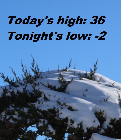
Today, it will be cloudy, with a high near 36 and a south southeast wind of 7 to 10 mph, gusting as high as 21 mph, the weather service said.
Tonight, there is an 80 percent chance of snow, mainly after midnight, with a low of minus 2. The wind chill may be between minus 8 and minus 13. It will be blustery, with a south southwest wind of 12 mph becoming north northwest 16 to 21 mph after midnight. Winds could gust as high as 37 mph. Less than an inch of snow is expected.
Thursday, snow is likely before noon, with a 70 percent chance of precipitation. Widespread blowing snow will occur mainly between 9 a.m. and noon, the weather service said. Temperatures will fall to around minus 2 by 3 p.m., with wind chill values between minus 18 and minus 27. It will be blustery, with a north northwest wind of 22 to 25 mph, gusting as high as 40 mph. From 1 to 3 inches of snow is expected..
Thursday night, there will be patchy blowing snow, with a low of minus 6, according to the weather service. The wind chill will be between minus 23 and minus 28. It will be blustery, with a northwest wind of 22 mph, gusting as high as 37 mph.
Friday, there will be patchy blowing snow with a high near 7, the weaher service said. It will be blustery, with a west northwest wind of 20 to 23 mph, gusting as high as 34 mph.
Friday night, there will be patchy blowing snow between 9 p.m. and 10 p.m., with a low of minus 2. It will be blustery.
Saturday, it will be mostly sunny and cold, with a high near 14, the weather service said.
Saturday night, it will be partly cloudy, with a low of 5, according to the weather service.
On Sunday, Christmas Day, it will be mostly sunny, with a high near 31, the weather service said.
Sunday night, it will be mostly cloudy, with a low of 17, according to the weather service.
Monday, it will be partly sunny, with a high near 25, the weather service said.
Monday night, it will be partly cloudy, with a low of 10, according to the weather service.
Tuesday, it will be mostly sunny, with a high near 35, the weather service said.