After the possibility of patchy freezing drizzle this morning, with some slick spots, the weather will be warmer today, and some of the snow may melt.
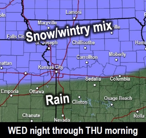
But there is a chance of a wintry mix and snow arriving Wednesday night into Thursday morning, according to the National Weather Service.
Wyandotte County is in the forecast area that could get light snow and ice on Wednesday night and Thursday, but there is still some uncertainty with surface temperatures, the weather service said.
A 1- to 2-degree temperature difference could alter the location of the snow and ice, according to the weather service. Motorists may need to be careful Thursday morning.
The next chance for accumulating snowfall and windy conditions will be possible late Friday into Saturday, the weather service said. Uncertainty remains about the details of this potential storm.
Dangerously cold temperatures are expected this weekend, with temperatures dipping down into the single digits and wind chills well below zero, according to the weather service.
Today, there will be areas of fog before noon, the weather service said. The high will be near 37 with a southwest wind of 8 to 10 mph.
Tonight, there may be patchy fog before 3 a.m., then areas of fog after 5 a.m., according to the weather service. The low will be around 26 with a southwest wind of 5 to 10 mph becoming north after midnight.
Wednesday, there may be patchy fog before 10 a.m., the weather service said. The high will be near 35 with a north wind of 6 mph becoming east in the morning.
Wednesday night, there is a 70 percent chance of rain showers and freezing rain, possibly mixed with sleet, before 3 a.m., then sleet likely, possibly mixed with freezing rain, according to the weather service. The low will be around 30 with an east northeast wind around 5 mph becoming north after midnight. Little or no ice accumulation is expected. New sleet accumulation of less than a half-inch is possible.
Thursday, it will be cloudy, then gradually becoming mostly sunny, with a high near 37 and a northwest wind of 5 to 7 mph, the weather service said.
Thursday night, the low will be around 25 with partly cloudy skies, according to the weather service.
Friday, there is a 40 percent chance of rain and snow between noon and 1 p.m., then a chance of rain after 1 p.m., with a high near 38, the weather service said.
Friday night, there is a 90 percent chance of rain before 7 p.m., then rain and snow showers between 7 p.m. and 8 p.m., then snow showers after 8 p.m., according to the weather service. The low will be around 20. It will be windy.
Saturday, there is a 70 percent chance of precipitation, the weather service said. Snow showers are possible, mainly before noon. The high will be near 20.
Saturday night, it will be partly cloudy with a low of minus 4, according to the weather service.
Sunday, it will be sunny and cold, with a high near 9, the weather service said.
Sunday night, it will be mostly clear, with a low around 1, according to the weather service.
On Monday, Martin Luther King Jr. holiday, it will be sunny with a high near 31, the weather service said.