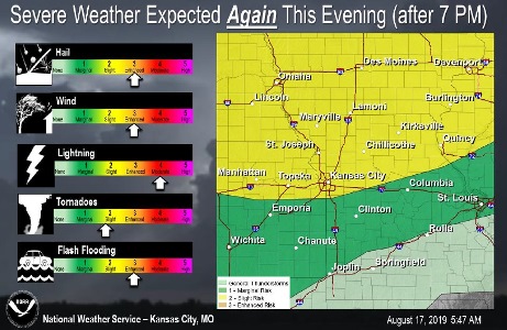
More storms will be possible on Saturday night, according to the National Weather Service. The area received about 1 to 2 inches of rain in a storm Friday night and Saturday morning.
All modes of severe weather will be possible, the weather service said.
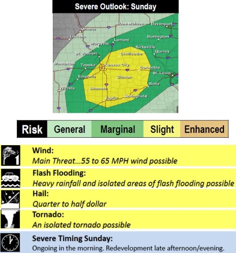
Strong to severe storms will be possible again on Sunday, and some may be ongoing during the morning hours, and possibly redevelop on Sunday afternoon, according to the weather service.
A flash flood watch remains in effect in Wyandotte County until 1 p.m. Saturday, the weather service said.
The Missouri River at Parkville, which includes Wyandotte County area, is currently in action stage, and is below flood stage. The Kansas River at 23rd Street is below action stage and below flood stage, and is projected to rise to action stage.
Today, the high will be near 88 with a heat index as high as 97, the weather service said, with a south wind of 7 to 9 mph. There will be a slight chance of showers and thunderstorms after 4 p.m.
Tonight, there is a 50 percent chance of showers and thunderstorms, with a low around 74 and a south wind of 6 to 10 mph, according to the weather service. Between a quarter to half-inch of rain is possible.
Sunday, there is a 40 percent chance of showers and thunderstorms, mainly before 1 p.m., the weather service said. The high will be near 91 with a heat index as high as 101. There will be a south wind of 6 to 8 mph. Less than a tenth of an inch of rain is possible.
Sunday night, there is a 30 percent chance of showers and thunderstorms, mainly before 1 a.m., with a low of 73, according to the weather service. Less than a tenth of an inch of rain is expected.
For more weather information, visit www.weather.gov.