Rain and storms moved through Wyandotte County on Wednesday morning, and there is a chance of more showers and storms after 3 p.m. today, according to the National Weather Service.
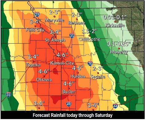
A line of storms moved through the area to the east, and there are similar storms in the forecast through Saturday. One to two inches of rain are possble tonight, the weather service said.
On Thursday night there could be another north-south line of storms moving through the area just after sunset, according to the weather service.
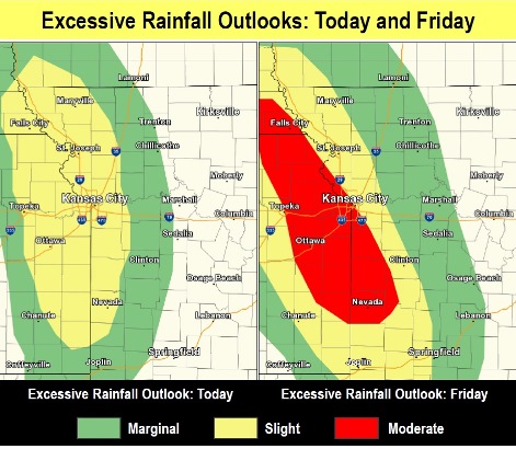
The chance of flash flooding will increase with each rain, as the ground will become more saturated, the weather service said.
The rivers in Wyandotte County on Wednesday morning were below flood stage. The Missouri River at Parkville, where the gauge is at I-435 over the Missouri River, between Wyandotte County and Platte County, was below flood stage, in the action stage. The Kansas River at 23rd Street, where the gauge is at Kansas Avenue near the state line, was below flood stage and below action stage.
Today, there is a 40 percent chance of showers and thunderstorms before noon, then a slight chance of showers and thunderstorms after 3 p.m., the weather service said. The high will be near 86 with a southeast wind of 6 to 11 mph. Less than a tenth of an inch of rain is expected.
Tonight, there is a 90 percent chance of showers and thunderstorms, mainly after 1 a.m., according to the weather service. Some of the storms may produce heavy rain. The low will be around 68 with an east southeast wind around 9 mph. Between 1 and 2 inches of rain are possible.
Thursday, there is a 60 percent chance of showers and thunderstorms, mainly before 1 p.m., the weather service said. The high will be near 84 with a south southeast wind of 9 to 13 mph, gusting as high as 22 mph. From a quarter to a half-inch of rain is possible.
Thursday night, there is a 70 percent chance of showers and thunderstorms, mostly after 1 a.m., according to the weather service. The low will be around 69 with a light southeast wind. Between a half and three-quarters of an inch of rain is possible.
Friday, there is a 60 percent chance of showers and thunderstorms, mainly before 1 p.m., the weather service said. The high will be near 78 with a light southeast wind. Between 1 and 2 inches of rain are possible.
Friday night, there is a 50 percent chance of showers and thunderstorms, with a low of 68, according to the weather service. Between three-quarters and 1 inch of rain are possible.
Saturday, there is a 30 percent chance of showers and thunderstorms before 1 p.m., with a high near 83, the weather service said.
Saturday night, it will be mostly clear, with a low of 65, according to the weather service.
Sunday, it will be sunny with a high near 85, the weather service said.
Sunday night, it will be mostly clear with a low of 65, according to the weather service.
Monday, it will be sunny with a high near 87, the weather service said.
Monday night, it will be partly cloudy with a low of 68, according to the weather service.
Tuesday, it will be mostly sunny, with a high near 88, the weather service said.