Missouri River flood warning issued for Thursday
Heavy rain is in the forecast for tonight, the National Weather Service said.
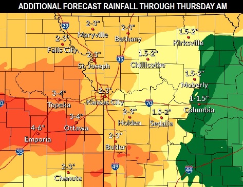
Almost an inch of rain fell in the last 24 hours. An additional 2 to 3 inches of rain is possible, according to the forecast through Wednesday.
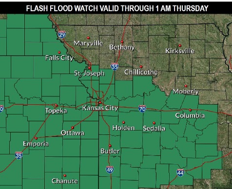
A flash flood watch is in effect for Wyandotte County through 1 a.m. Thursday, May 9, according to the weather service. Residents should monitor the forecasts and be prepared to take action if a flash flood warning is issued, the weather service said.
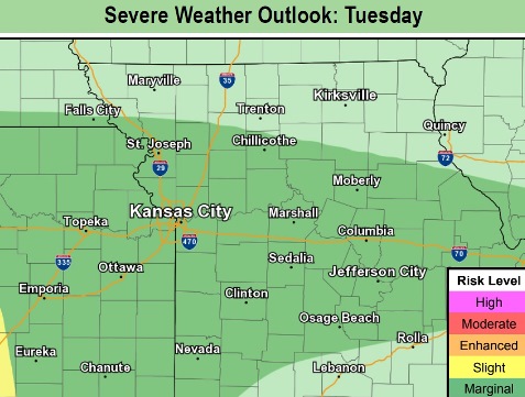
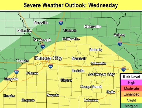
According to the forecast, there may be on-and-off showers and storms through Tuesday. A few strong storms are possible Tuesday and Wednesday, according to the weather service.
The weather service has issued a flood warning for the Missouri River at Parkville, Missouri, which includes Wyandotte County. This warning is in effect from Thursday afternoon to Wednesday, May 15. At 8:45 a.m. Tuesday, the stage was 21.7 feet, where flood stage is 25 feet. Minor flooding is forecast, the weather service stated.
Residents are advised not to drive through flowing water, to turn around and take an alternate route. They also are advised to stay indoors during thunderstorms.
Today, there is a 90 percent chance of showers and thunderstorms. Rain and storms are possible before noon, then between noon and 3 p.m., followed by showers and a possible thunderstorm after 3 p.m., the weather service said. Some storms could be severe, with heavy rain. The high will be near 69, with an east wind around 8 mph. Between a tenth and quarter-inch of rain is possible during the daytime.
Tonight, there is a 100 percent chance of showers and possibly a thunderstorms. Some of the storms may produce heavy rain, according to the weather service. The low will be around 62 with an east wind of 7 to 9 mph. Between a quarter and half-inch of rain is possible.
Wednesday, there is a 70 percent chance of showers and possibly and thunderstorm, the weather service said. Some storms may be severe, with heavy rain. The high will be near 72, with a south wind of 11 to 13 mph. Between a quarter and half-inch of rain is possible.
Wednesday night, there is a 70 percent chance of showers and a possible thunderstorm before 1 a.m., then a chance of showers and thunderstorms between 1 a.m. and 4 a.m., then more showers after 4 a.m., according to the weather service. Some of the storms may produce heavy rain. The low will be around 50, with a south wind of 8 to 11 mph becoming north northwest after midnight. Between a quarter and half-inch of rain is possible.
Thursday, there is a 20 percent chance of showers before 1 p.m., with a high near 56, the weather service said. A north northeast wind of 13 mph will gust as high as 21 mph.
Thursday night, it will be mostly cloudy with a low of 44, according to the weather service.
Friday, it will be mostly sunny, with a high near 63, the weather service said.
Friday night, it will be partly cloudy, with a low of 47, according to the weather service.
Saturday, it will be partly sunny, with a high of 68, the weather service said.
Saturday night, the low will be around 50 with mostly cloudy skies, according to the weather service.
Sunday, it will be mostly sunny, with a high near 69, the weather service said.
Sunday night, it will be mostly clear, with a low of 50, according to the weather service.
Monday, it will be sunny, with a high near 71, the weather service said.