More rain is expected Monday, and through the mid to late week, according to the National Weather Service forecast.
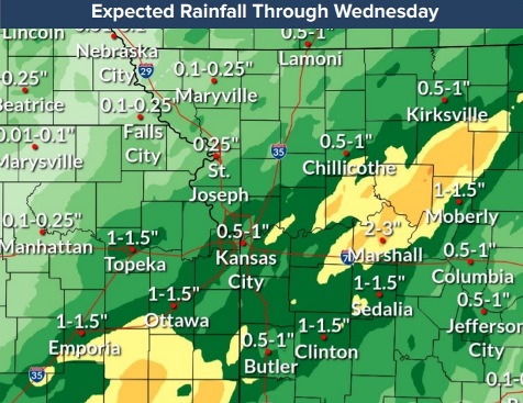
Another one to three inches of rain is forecast through midweek, which may aggravate ongoing minor to major flooding on multiple rivers across the region, the weather service said.
Off-and-on thunderstorms are expected through the day on Monday, according to the weather service. Severe weather is not anticipated. Lightning will be a hazard. Winds will be light.
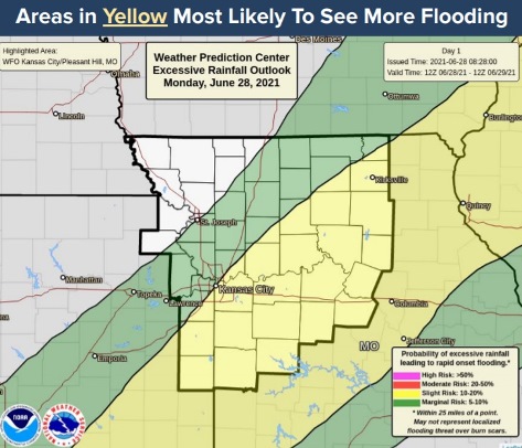
Areas that see even brief periods of heavy rain could see some flooding, since the ground is still saturated in many areas, the weather service said.
More showers and thunderstorms are expected along and southeast of I-35, and more flooding will be possible through mid to late week, according to the weather service. Southern parts of the region are expected to have more flood risk.
All the major rivers in Wyandotte County are currently below action stage. In Platte County, the Platte River near Platte City was in major flood stage on Monday morning.
Today, there is a 60 percent chance of precipitation with showers and thunderstorms likely during the day, and possibly a thunderstorm after 4 p.m., the weather service said. The high will be near 81 with a light east wind. Between a tenth and quarter of an inch of rain is possible.
Tonight, there is a 70 percent chance of showers and thunderstorms, with more showers likely and possibly a thunderstorm after 1 a.m., according to the weather service. The low will be around 71. A south southeast wind of 5 mph will become calm in the evening. Between a quarter and half-inch of rain is possible.
Tuesday, there is a 70 percent chance of showers and possibly a thunderstorm, with a high near 80 and a calm wind, the weather service said. Between a half and three-quarters of an inch of rain is possible.
Tuesday night, there is a 50 percent chance of showers and thunderstorms, mainly after 1 a.m., according to the weather service. The low will be around 70 with a calm wind. Between a tenth and quarter-inch of rain is possible.
Wednesday, there is a 70 percent chance of showers and possibly a thunderstorm, with a high near 82 and a light and variable wind, the weather service said. Between a quarter and half-inch of rain is possible.
Wednesday night, there is a 40 percent chance of showers and thunderstorms, with a low of 68, according to the weather service. Between a tenth and quarter-inch of rain is possible.
Thursday, there is a 40 percent chance of showers, with a high near 84, the weather service said.
Thursday night, it will be partly cloudy, with a low of 66, according to the weather service.
Friday, it will be sunny, with a high near 83, the weather service said.
Friday night, it will be mostly clear, with a low of 61, according to the weather service.
Saturday, it will be sunny, with a high near 82, the weather service said.
Saturday night, it will be mostly clear, with a low of 62, according to the weather service.
On Sunday, Independence Day, it will be sunny, with a high near 86, the weather service said.