More flooding is expected in coming days along the Missouri River and its tributaries, according to Corps of Engineers officials.
Officials said at a Friday telephone news conference that there has been significant rainfall in the past few days, and additional rainfall this weekend could result in flooding here.
The Kansas City District of the Corps of Engineers has issued 400,000 sandbags to Kansas and Missouri communities, along with deploying pumps and barriers. It also has provided engineering teams to help communities.
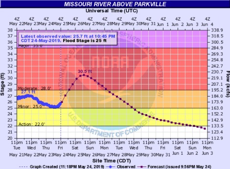
When flooding began earlier this week, 16 levees east of Kansas City had overtopped or breached, and seven more were reported on May 24, according to officials.
The next day will bring showers, thunderstorms and heavy rain in the region. Friday’s storms were predicted to result in 1.5 inches of rain, with Saturday bringing one-half to 1.5 inches of rain.
More precipitation was in the forecast for Sunday, Monday and Tuesday, while Wednesday to Friday will see very little rain. One week from now, on Saturday, June 1, rainfall will start again across the Missouri River basin, officials said.
Reservoirs in South Dakota and in Kansas to release more water into the Missouri and Kansas rivers
There were heavy inflows of water into lower parts of the Missouri River basin on Thursday, resulting in a need to increase the releases from Gavins Point dam from 55,000 to 60,000 cubic feet per second, according to Corps of Engineers officials.
On Friday, there were decreased flowed from Garrison dam, dropping from 30,000 to 25,000 on Friday and another 5,000 decrease on Saturday, according to officials. Pools at Oahe and Ft. Randall will be pushed into the exclusive flood control zones, where they will remain for the next several weeks.
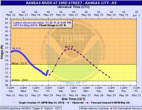
On Saturday, May 25, the Corps of Engineers plans to begin flood water releases from Perry Lake in Perry, Kansas, if there is heavy rain this weekend that fills the reservoir’s remaining storage capacity, officials said.
If heavy rains necessitate releases, Perry Lake will slowly ramp up water releases through the outlet works, according to officials. Releases could be up to 20,000 cubic feet per second into the Kansas River. Officials said the volume of releases would depend on inflows into the reservoir.
There also is the potential for releases from Tuttle Creek dam in Manhattan, Kansas, beginning Monday, May 27, through an outlet works known as “the tubes,” officials said.
Water levels are high at the reservoirs, and anyone who is on or near the water is asked to wear a life jacket, officials said. There are risks associated with high water, including floating debris and obstructions covered by water, which can create dangerous boating conditions, according to officials.
People are asked not to drive or walk into flood waters on the road, to turn around and take another route. People should never enter standing or moving water to cross a road.
For up-to-date weather information, visit www.weather.gov.