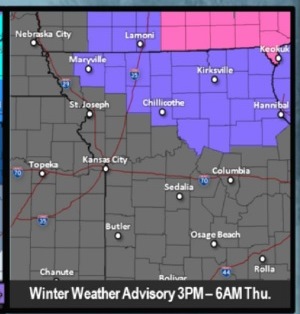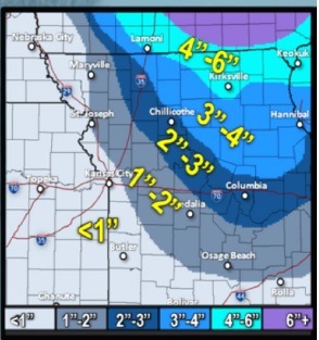
Wyandotte County is in an area that may get less than one inch of snow on Wednesday night or Thursday morning, according to the National Weather Service.
The weather service said a slight, or 20 percent, chance of rain will be after 5 p.m. Wednesday. The high will be near 54, with a light south wind becoming south southwest 8 to 13 mph in the morning, according to the weather service.
The weather service forecast said that a wintry mix is possible this evening and Thursday as temperatures start falling. By 6 p.m., temperatures should be about 43 degrees, and by 9 p.m., 33 degrees, according to the weather service. At midnight, the temperature may be 25 degrees.
Falling temperatures Wednesday night may lead to icy patches on roadways and sidewalks especially where rain and melting snow falls Wednesday evening, the weather service said.
The wintry mix may change to all snow after 1 a.m., according to the weather service. The overnight low will be around 14, and the winds will change to the north and will be 19 to 24 mph, gusting as high as 37 mph.
The slight or 10 percent chance of snow continues before 7 a.m. Thursday, the weather service said. Thursday’s high will be near 18, and the wind chill will be between minus 3 and 3. The north wind will be 14 to 20 mph with gusts as high as 31 mph.
Cold weather will continue Friday, when the high will be near 19.
Saturday, there is a 50 percent chance of snow after 7 a.m., according to the forecast. Snow is also likely Saturday night and Sunday, and could continue into next week, according to the forecast.
Widespread winter weather is likely Saturday afternoon into early next week, although details such as timing, precipitation type and snow or ice amounts are unknown at this time, the weather service said.