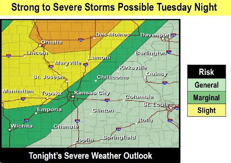
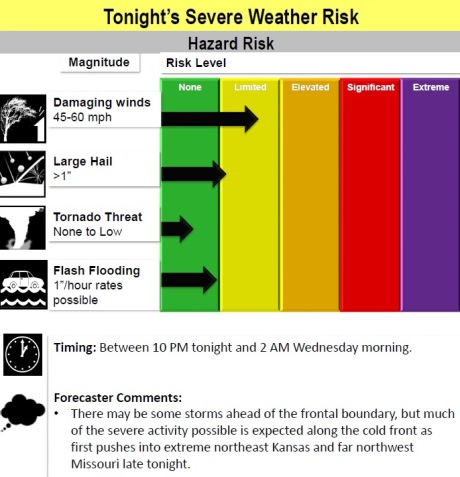
Wyandotte County is at marginal risk for severe weather late tonight into Wednesday morning, according to the National Weather Service.
The main effect will be damaging winds, while hail and tornado threats are low, the weather service said.
Storm chances will continue throughout the week, especially Wednesday night, mainly south of I-70 and Friday, across the area, according to the weather service. No severe weather is expected at this time, though.
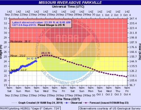
The Missouri River at Parkville, whose gauge is on I-435 over the Missouri River between Wyandotte County and Platte County, is currently in action stage and is projected to go into minor flood stage. A flood warning is in effect starting Tuesday evening through Friday morning.
Residents are advised to avoid flooded roads and take another route.
Today, it will be mostly sunny with a high near 82 and a south wind of 6 to 13 mph, gusting as high as 20 mph, the weather service said.
Tonight, there is a 50 percent chance of showers and thunderstorms after 10 p.m., with a low of 67 and a south wind of 7 to 10 mph becoming west southwest after midnight, according to the weather service. Winds may gust as high as 20 mph. Less than a tenth of an inch of rain is in the forecast.
Wednesday, there is a 30 percent chance of showers and thunderstorms, mainly after 1 p.m., the weather service said. The high will be near 81 with a light and variable wind becoming north northeast 5 to 8 mph in the morning. New rainfall amounts of less than a tenth of an inch are possible.
Wednesday night, there is a 30 percent chance of showers and thunderstorms, mainly before 1 a.m., according to the weather service. The low will be around 59 with a calm wind. Less than a tenth of an inch of rain is possible.
Thursday, it will be mostly sunny, with a high near 76 and a calm wind becoming southeast around 6 mph in the afternoon, the weather service said.
Thursday night, there is a 20 percent chance of showers and thunderstorms after 1 a.m., with a low of 69, according to the weather service.
Friday, there is a 40 percent chance of showers and thunderstorms, with a high near 83, the weather service said.
Friday night, there is a 60 percent chance of showers and thunderstorms likely, mainly before 1 a.m., with a low of 63, according to the weather service.
Saturday, there is a 30 percent chance of showers and thunderstorms, with a high near 77, the weather service said.
Saturday night, there is a 30 percent chance of showers and thunderstorms before 1 a.m., with a low of 69, according to the weather service.
Sunday, it will be mostly sunny, with a high near 83, the weather service said.
Sunday night, it will be partly cloudy, with a low of 73, according to the weather service.
Monday, it will be partly sunny, with a high near 84, the weather service said.