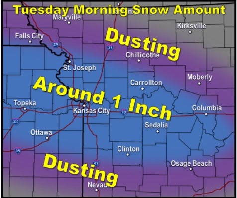
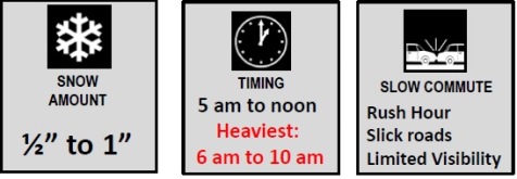
Light to moderate snow is expected to develop early Tuesday morning across the Kansas City area, dropping a quick half-inch to around an inch of snow within a relatively short amount of time, according to the National Weather Service.
Wyandotte County is under a winter weather advisory from 6 a.m. to noon Tuesday, according to the weather service.
Drivers should pay close attention to quickly deteriorating weather conditions if driving Tuesday morning, according to the weather service. They should be prepared for snow-covered roads and reduced visibility, the weather service said.
Tonight’s forecast is a 30 percent chance of flurries before 3 a.m., then a chance of snow showers mainly after 4 a.m., according to the weather service. Tonight’s low is around 10 with a wind chill between minus 1 and 4.
Tuesday, there is a 50 percent chance of snow showers, mainly before 11 a.m., the weather service said. The high will be near 14, with a wind chill of between minus 5 and 2. A north northeast wind will be 8 to 11 mph.
Tuesday night, the low will be around 2, with a wind chill between minus 5 and zero, according to the weather service. A north northeast wind will be 3 to 7 mph.
Wednesday, it will be mostly sunny with a high near 19, the weather service said. The wind chill will be between minus 8 and 2, with an east wind of 3 to 7 mph.
Wednesday night, it will be mostly cloudy with a low of 15 and an east southeast wind of 6 to 8 mph, according to the weather service.
Thursday, there is a 20 percent chance of snow before noon, with a high near 29, the weather service said.
Thursday night, the low will be around 16 with mostly cloudy skies, according to the weather service.