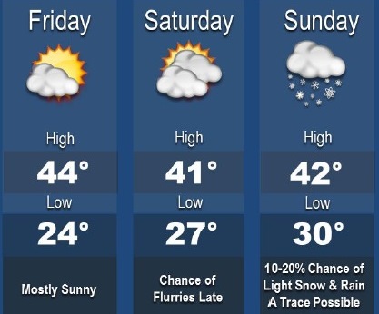
Flurries will be possible Saturday night changing to light snow, then rain and snow on Sunday morning in some areas, according to the National Weather Service.
However, these flurries will be centered more in other areas of the region, and will probably be only briefly if at all in the Kansas City area, the weather service said.
The snow showers will change to a rain and snow mix on Sunday morning, moving to the east by the afternoon, according to the weather service. A trace to a dusting is possible, mainly east of Kansas City, and it will melt quickly with high temperatures in the lower 40s, the weather service said.
Today, look for sunny skies and a high near 43, with a west wind of 9 to 14 mph, gusting to as high as 22 mph, according to the weather service.
Tonight, the low will be about 27 with a west northwest wind of 8 to 11 mph, the weather service said.
Saturday, the high will be near 41 with partly sunny skies, according to the weather service. A northwest wind of 9 to 13 mph will gust as high as 22 mph.
Saturday night, the low will be around 29 with mostly cloudy skies, the weather service said, and a west northwest wind of 6 to 8 mph.
Sunday’s forecast is partly sunny with a high of 43, and a northwest wind of 7 to 15 mph, gusting as high as 25 mph, the weather service said.
Sunday night, the low will be 28 with partly cloudy skies, according to the weather service.
Monday’s forecast is mostly sunny with a high near 52, the weather service said. Monday night, the low will be around 30.