Light snow is expected to form over eastern Kansas this evening, according to the National Weather Service.
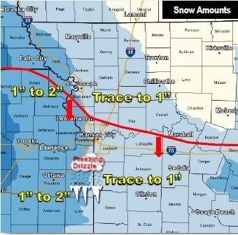
The storm will rotate northeast across west central and northwest Missouri after midnight. Around an inch of snow is possible near the Kansas-Missouri state line, the weather service said. Amounts decrease to the east.
As the snow ends from south to north Thursday morning, light freezing drizzle may form south of the red line above and leave a thin layer of ice again, according to the weather service.
Today, skies will be cloudy, with a high near 30 and a calm wind that will change to southeast 5 to 7 mph in the afternoon, the weather service said.
Tonight, there is a 30 percent chance of snow, mainly after midnight, with a low of 25, according to the weather service.
Thursday, expect a 50 percent chance of patchy snow and freezing drizzle, according to the weather service. The high will be near 30 with an east wind of 9 mph becoming north northeast in the afternoon.
Thursday night’s low will be about 20, the weather service said.
On Friday, the forecast calls for a high near 28, and a north wind of 11 to 13 mph, gusting as high as 18 mph, according to the weather service. Cloudy skies will gradually become mostly sunny.
Friday night, the low will be around 15, the weather service said.
Saturday, skies will be mostly sunny with a high near 35, according to the weather service. Saturday night, the low will be around 27.
Sunday, it will be partly sunny with a high of 43, the weather service said. Sunday night, the low will be around 27.
On Monday, there will be a 30 percent chance of rain and snow with a high near 35, according to the weather service. Monday night’s low will be around 22, the weather service said.
Tuesday, expect partly sunny skies with a high near 36, according to the weather service.