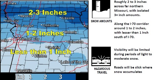
About 1 to 2 inches of snow are possible along the I-70 corridor on Saturday night into Sunday morning, according to the National Weather Service. A trace to less than 1 inch is likely south of I-70.
The quick-moving weather system will see higher snowfall amounts to the north, including St. Joseph, Mo., with lighter amounts to the south, the weather service said. Wyandotte County appears to be on the line between the moderate to light snowfall areas.
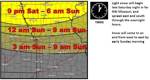
The forecast calls for light snow to begin possibly around 3 a.m. Sunday in the Wyandotte County area and it could last to about 9 a.m. Sunday, according to the weather service. The storm may be moving from west to the east, and also from the north to the south, forecasters believe.
Visibility may be limited during periods of light to moderate snow, according to the weather service. Roads will be slick where snow accumulates.
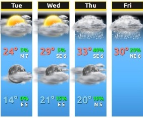
Today, the high will be near 33 with partly sunny skies and a north wind of 6 mph, the weather service said.
Tonight, the low will be around 21 with an 80 percent chance of snow showers, mostly after midnight, according to the weather service. There will be a northeast wind of 5 to 8 mph. A new snow accumulation of around an inch is possible.
Sunday, there is a 50 percent chance of snow, mainly before 9 a.m., the weather service said. The skies will gradually clear and there will be a high near 32, with a north wind of 5 to 10 mph becoming west northwest in the afternoon.
Sunday night, it will be mostly clear with a low of 19, according to the weather service. There will be a west southwest wind of 5 to 7 mph.
Monday, Christmas Day, it will be partly sunny with a high near 33 and a light and variable wind becoming southeast around 5 mph in the afternoon, the weather service said.
Monday night, the low will be around 14 with mostly cloudy skies, according to the weather service.
Tuesday, it will be partly sunny with a high near 21, the weather service said.
Tuesday night, the low will be around 10 with mostly cloudy skies, according to the weather service.
Wednesday, the high will be near 26 with mostly sunny skies, the weather service said.
Wednesday night, the low will be around 18 with mostly cloudy skies, according to the weather service.
Thursday, the high will be near 32 with mostly cloudy skies, the weather service said.
Thursday night, it will be mostly cloudy with a low of 18, according to the weather service.
Friday, the high will be near 29 with partly sunny skies, the weather service said.
For more weather information, visit www.weather.gov or listen to a weather radio.