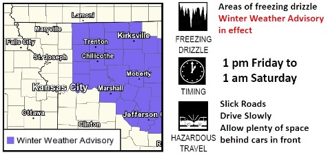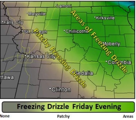
Friday evening could see periods of freezing drizzle across the central and northern parts of the region, including a slight chance in Wyandotte County, according to the National Weather Service.
Light accretions of ice are possible, which will make all surface slick and hazardous, according to the weather service.
Bitterly cold temperatures, with wind chills in the -25 to -35 degree range are expected for the weekend and into next week, the weather service said.
Temperatures will take a rather dramatic turn to the colder as the new year approaches, according to the weather service.
Daytime highs this weekend will struggle to reach double digits, and overnight lows could drop as low as 5 to 15 degrees below zero, the weather service said.
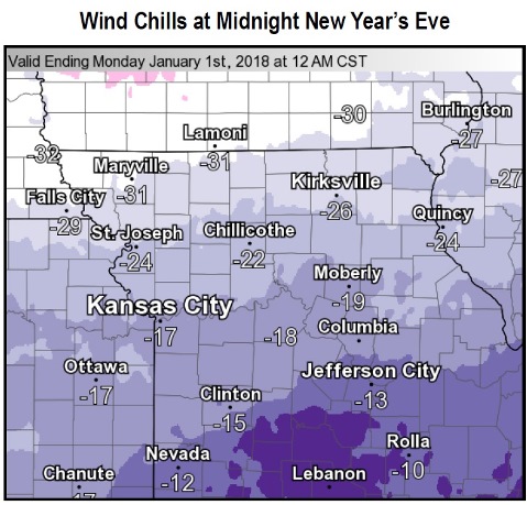
Wind chill values this weekend could drop to 25 to 35 degrees below zero, with New Year’s Eve Night being the coldest of the upcoming nights, according to the weather service.
Expect temperatures to be in the minus-5 to positive-5 degree range at midnight New Year’s Eve, with wind chills ranging from 15 to 35 degrees below zero, the weather service said.
Today, according to the weather service, there will be a slight chance of freezing drizzle after noon. The high will be near 30 with a light and variable wind becoming south 5 to 8 mph.
Tonight, there is a chance of flurries before 8 p.m., according to the weather service. The low will be around 8 with a wind chill between minus 6 and 4. A light northeast wind will become north 9 to 14 mph in the evening, and winds could gust as high as 20 mph.
Saturday, it will be mostly sunny and cold, with a high near 10, the weather service said. Wind chill values will be between minus 3 and minus 8. A north wind of 8 to 14 mph may gust as high as 20 mph.
Saturday night, it will be mostly cloudy with a low of minus 1, according to the weather service. Wind chill values will be between minus 6 and minus 13, with a northeast wind of about 8 mph.
Sunday, it will be mostly sunny and cold with a high of 6 and a north wind of 7 to 9 mph, the weather service said.
Sunday night, New Year’s Eve, it will be mostly clear with a low of minus 9, according to the weather service.
On Monday, New Year’s Day, it will be sunny and cold with a high near 5, the weather service said.
Monday night, the low will be around minus 5, according to the weather service.
Tuesday, it will be mostly sunny with a high near 19, the weather service said.
Tuesday night, the low will be around 9, according to the weather service.
Wednesday, it will be mostly sunny with a high near 19, the weather service said.
Wednesday night, the low will be around 1, according to the weather service.