The temperature was 67 at 9 a.m. Monday in Wyandotte County, according to the National Weather Service, with changes coming today.
The Presidents Day forecast calls for gusty south winds to keep bringing Gulf moisture north, fueling scattered showers and isolated non-severe thunderstorms across the region today, the weather service said.
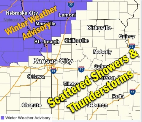
Tonight, a cold front will settle into the far north part of the region, resulting in accumulating freezing rain starting around 9 a.m. where the winter weather advisory has been issued, according to the weather service. Up to two-tenths of an inch of ice accumulation is possible within the advisory area tonight into Tuesday, the weather service said. However, Wyandotte County and the Kansas City area are not part of the winter weather advisory area, but are south of it. The weather forecast in Wyandotte County calls for rain and thunderstorms.
On Tuesday, a round of accumulating ice will end by noon, but the cold front will likely finish sweeping across the area Tuesday afternoon and evening, allowing for light accumulations of a wintry mix of precipitation on the back of the system as it moves east, according to the weather service.
The forecast for Monday, Presidents Day, is a 60 percent chance of showers and thunderstorms, then showers likely and possibly a thunderstorm after 5 p.m., the weather service said. The temperature will fall to around 46 by 4 p.m. A southwest wind of 7 to 15 mph will become north in the afternoon. Winds may gust as high as 29 mph.
Tonight, there is a 100 percent chance of showers and possibly a thunderstorm, according to the weather service. The low will be around 41, with a north wind of 5 to 11 mph becoming south after midnight. Between a quarter and half-inch of rain is possible.
Tuesday, there is an 80 percent chance of showers, mainly before 10 a.m., the weather service said. Temperatures will fall to around 33 by 5 p.m. A west southwest wind around 14 mph will become north northwest in the afternoon, and winds may gust as high as 22 mph. Between a quarter and half-inch of rain is possible.
Tuesday night, it will be mostly cloudy with a low of 19, and a north wind of 11 to 14 mph, gusting as high as 22 mph, according to the weather service.
Wednesday, it will be partly sunny, with a high near 33, and a north northeast wind of 9 to 11 mph, the weather service said.
Wednesday night, there will be a 40 percent chance of snow showers before 2 a.m., then a chance of freezing rain, according to the weather service. The low will be 25. Precipitation amounts are expected to be less than a tenth of an inch.
Thursday, there is a 30 percent chance of freezing rain before 11 a.m., then a chance of rain showers between 11 a.m. and noon, the weather service said. The high will be near 39.
Thursday night, there is a 50 percent chance of rain showers before 11 p.m., then a chance of rain and snow showers between 11 p.m. and 1 a.m., then a chance of snow showers after 1 a.m., according to the weather service. The low will be around 32.
Friday, there is a 40 percent chance of showers before midnight, with a low of 35, the weather service said.
Saturday, there is a 40 percent chance of rain and snow showers, with a high near 52, the weather service said.
Saturday night, there is a 60 percent chance of showers with a low of 35, according to the weather service.
Sunday, the high will be near 54 with mostly cloudy skies, the weather service said.