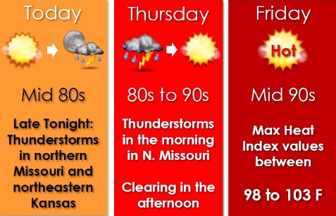
Today, Wyandotte County will get a break from extremely hot weather, with a high near 85, according to the National Weather Service.
Thunderstorms are possible later tonight, likely after midnight, across portions of northeastern Kansas and northern Missouri, the weather service said.
A warm-up will begin Thursday through the weekend. Heat index values are expected to reach the upper 90s and lower 100s Friday afternoon and Saturday.
A 20 percent chance of showers and thunderstorms is possible after 4 a.m. tonight, with a low of 71, according to the weather service.
Thursday, there is a 20 percent chance of showers and thunderstorms before 1 p.m., with a high near 93, the weather service said. There will be a southeast wind of 8 to 13 mph, gusting to 21 mph.
Thursday night, the low will be around 75 with a south wind of 9 to 11 mph, according to the weather service.
Friday, the high will be near 95 with a south wind of 10 to15 mph, gusting to 24 mph, the weather service said.
Friday night, the low will be around 75, according to the weather service.
Saturday, skies will be sunny with a high near 95, the weather service said.
Saturday night, the low will be around 75, according to the weather service.
Sunday, it will be sunny with a high near 94, the weather service said.
Sunday night, the low will be around 74, according to the weather service.
Monday, the high will be near 92 with mostly sunny skies, the weather service said.
Monday night, there is a 30 percent chance of showers and thunderstorms, with a low of 71, according to the weather service.
Tuesday, there is a 30 percent chance of showers and thunderstorms, with a high near 88, the weather service said.