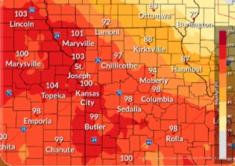
Temperatures rising to about 93 today, plus strong to severe thunderstorms early Saturday, are in today’s forecast from the National Weather Service.
The heat index could rise to as high as 101 today, the weather service said.
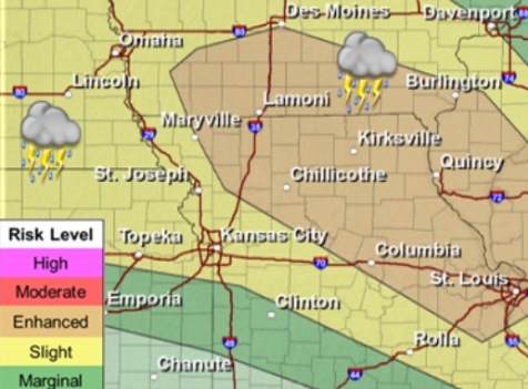
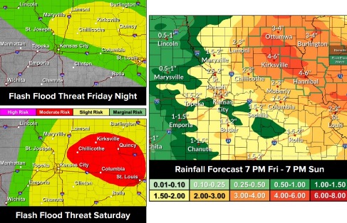
Mainly after 4 a.m. Saturday, strong to severe thunderstorms are possible. Heavy rain, flash flooding, large hail, damaging winds and a few tornadoes are possible, according to the weather service. From a quarter to a half-inch of rain is possible.
More showers and storms are possible Saturday, Saturday night and Sunday, according to the weather service.
Today, it will be mostly sunny, with a high near 93 and heat index values as high as 101, the weather service said. A south southwest wind of 6 to 13 mph will gust as high as 21 mph.
Tonight, there is a 60 percent chance of showers and thunderstorms, mainly after 4 a.m., according to the weather service. The low will be around 72 with a south southwest wind of 7 to 11 mph, gusting as high as 20 mph. Between a quarter and half-inch of rain is possible.
Saturday, there is an 80 percent chance of showers and thunderstorms, with a high of 81, the weather service said. A southwest wind will be 6 to 8 mph changing to east in the morning. Between 1 and 2 inches of rain are possible.
Saturday night, there is a 60 percent chance of showers and thunderstorms before 10 p.m., then showers likely and possibly a thunderstorm between 10 p.m. and 1 a.m., followed by a chance of showers and thunderstorms after 1 a.m., according to the weather service. The low will be around 66 with a northwest wind around 6 mph. Between a quarter and half-inch of rain is possible.
Sunday, there is a 50 percent chance of showers and thunderstorms, with a high near 74, the weather service said. A north northwest wind of 8 to 10 mph will gust as high as 20 mph. Less than a tenth of an inch of rain is expected.
Sunday night, there is a 20 percent chance of showers and thunderstorms before 10 p.m., then a slight chance of showers between 10 p.m. and 1 a.m., according to the weather service. The low will be around 62.
Monday, the high will be near 78, the weather service said.
Monday night, the low will be around 64, according to the weather service.
Tuesday, it will be sunny, with a high near 88, the weather service said.
Tuesday night, it will be partly cloudy, with a low of 74, according to the weather service.
Wednesday, there will be a 30 percent chance of showers and thunderstorms, with a high near 91, the weather service said.
Wednesday night, there is a 40 percent chance of showers and storms, with a low of 73, according to the weather service.
Thursday, there is a 50 percent chance of showers and thunderstorms, with a high near 86, the weather service said.