Today’s high could reach 77, according to the National Weather Service forecast.
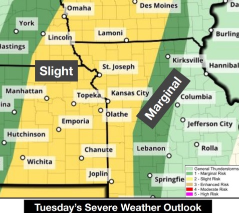
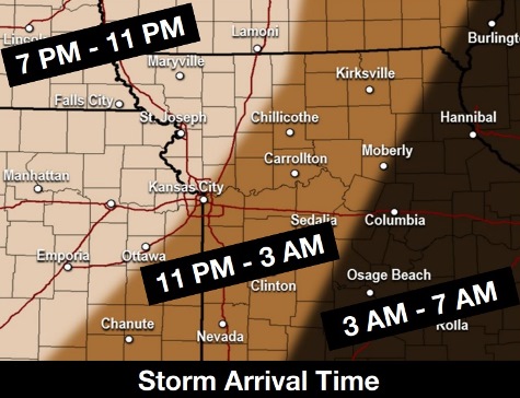
Storms may move in tonight, with some storms strong to severe, the weather service said.
In Wyandotte County, there is a slight chance for strong to severe storms between 7 p.m. tonight and 4 a.m. Wednesday, according to the weather service.
The main hazards of the storm are high winds, quarter-size hail and a possible tornado, the weather service said.
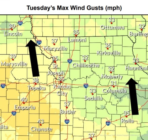
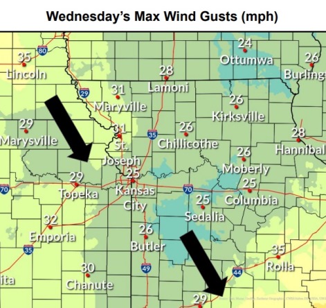
This afternoon, winds may gust up to 33 mph, and high wind gusts may continue tonight and on Wednesday, the weather service said.
A dramatic change in temperatures will occur as a cold front moves through, and temperatures will fall to around 44 by 5 p.m. Wednesday, according to the weather service.
Temperatures could drop below freezing at night, the weather service said. Wednesday night’s temperature will see a low of around 33, and Thursday night’s low will be about 31.
To follow any changes in the weather, visit www.weather.gov.
Today, the high will be near 77, the weather service said. It will be breezy, with a south wind of 10 to 15 mph increasing to 18 to 23 mph in the afternoon. Winds may gust as high as 33 mph.
Tonight, there is an 80 percent chance of showers and possibly a thunderstorm after midnight, according to the weather service. The low will be 52, with a south wind of 13 to 23 mph, gusting as high as 34 mph. Between a quarter and half-inch of rain is possible.
Wednesday, there is an 80 percent chance of showers and possibly a thunderstorm before 1 p.m., then a chance of showers, the weather service said. The temperature will fall to around 44 by 5 p.m. A south southwest wind of 6 to 16 mph will become northwest in the morning. Winds may gust as high as 29 mph. Between a tenth and quarter-inch of rain is possible, except higher amounts are possible during a thunderstorm.
Wednesday night, there is a 30 percent chance of rain before 1 a.m., with a low of 33, according to the weather service. A west northwest wind of 13 to 16 mph will gust as high as 26 mph. Less than a tenth of an inch of rain is possible.
Thursday, it will be partly sunny, with a high near 50 and a northwest wind of 10 to 14 mph, gusting as high as 23 mph.
Thursday night, it will be mostly clear, with a low of 31, according to the weather service.
Friday, it will be mostly sunny, with a high near 61, the weather service said.
Friday night, there is a 60 percent chance of rain, mainly before 1 a.m., according to the weather service. The low will be around 42.
Saturday, there is a 30 percent chance of rain before 1 p.m., with a high near 60, the weather service said.
Saturday night, it will be mostly clear, with a low of 38, according to the weather service.
Sunday, it will be mostly sunny, with a high near 66, the weather service said.\
Sunday night, it will be partly cloudy, with a low of 43, according to the weather service.
Monday, there is a 30 percent chance of rain, with a high near 60, the weather service said.