
The National Weather Service has issued a heat advisory for Wyandotte County from noon Friday through 8 p.m. Sunday.
The heat index today may be as high as 107, the weather service said. On Saturday, the heat index may reach 105.
Residents are advised to drink plenty of fluids, stay in an air-conditioned room, stay out of the sun and check on relatives and neighbors, according to the weather service. Young children and pets should never be left unattended in vehicles.
Those who work or spend time outside should take extra precautions, the weather service said. When possible, reschedule strenuous activities to early morning or evening. Know the signs and symptoms of heat exhaustion and heat stroke; wear lightweight and loose-fitting clothing when possible. To reduce the risk of heat illness during outdoor work, the Occupational Safety and Health Administration recommends scheduling frequent rest breaks in shaded or air-conditioned places. Anyone overcome by heat should be moved to a cool and shaded area. Heat stroke is an emergency and persons may call 911.
The surrounding area including Johnson and Leavenworth counties also is under the heat advisory.
The weather service said heat and humidity will increase through the weekend.
Chances for rain and thunderstorms will be Sunday into Monday, bringing a brief respite from the oppressive heat, according to the weather service.
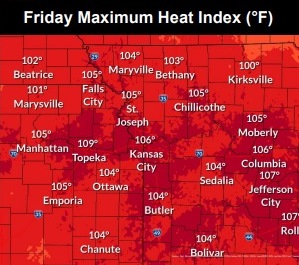
Today, it will be sunny and hot, with a high near 100, the weather service said. The heat index will be as high as 107. A south southwest wind of 5 to 11 mph will gust as high as 21 mph.
Tonight, it will be mostly clear, with a low of 78 and a south southwest wind of 7 to 10 mph, gusting as high as 21 mph, according to the weather service.
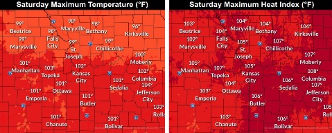
Saturday, it will be sunny and hot, with a high near 101 and heat index values as high as 105, the weather service said. A south southwest wind of 7 to 15 mph will gust as high as 25 mph.
Saturday night, there will be increasing clouds, with a low of 82, according to the weather service. A south southwest wind will be 10 to 14 mph, gusting as high as 29 mph.
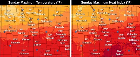
Sunday, there is a 20 percent chance of showers and thunderstorms after 1 p.m., with a high near 96, the weather service said. A southwest wind of 6 to 8 mph will become north in the afternoon. Winds may gust as high as 20 mph.
Sunday night, there is a 60 percent chance of showers and thunderstorms, then more showers and possibly a thunderstorm after 1 a.m., according to the weather service. It will be mostly cloudy, with a low of 72. Between a tenth and quarter-inch of rain is possible.
Monday, there is a 40 percent chance of showers, with a high near 87, the weather service said.
Monday night, there is a 40 percent chance of showers after 1 a.m., with a low of 71, according to the weather service.
Tuesday, there is a 30 percent chance of showers before 1 p.m., with a high near 94, the weather service said.
Tuesday night, there is a 30 percent chance of showers after 1 a.m., with a low of 76, according to the weather service.
Wednesday, there is a 30 percent chance of showers, with a high near 95, the weather service said.
Wednesday night, there is a 50 percent chance of showers, with a low of 70, according to the weather service.
Thursday, there is a 40 percent chance of showers, with a high near 84,the weather service said.